
IMAGES TAKEN NEAR TO
Godolphin Cross, HELSTON, TR13 9QQ
Introduction
This page details the photographs taken nearby to TR13 9QQ by members of the Geograph project.
The Geograph project started in 2005 with the aim of publishing, organising and preserving representative images for every square kilometre of Great Britain, Ireland and the Isle of Man.

There are currently over 7.5m images from over14,400 individuals and you can help contribute to the project by visiting https://www.geograph.org.uk
Image Map
Images are licensed for reuse under creativecommons.org/licenses/by-sa/2.0
Notes
- Clicking on the map will re-center to the selected point.
- The higher the marker number, the further away the image location is from the centre of the postcode.
Image Listing (26 Images Found)
Images are licensed for reuse under creativecommons.org/licenses/by-sa/2.0
Image
Details
Distance
1
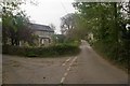
Ruthdower
Lane junction outside Godolphin Cross. Ruthdower Cottage on the left.
Image: © Ian Capper
Taken: 23 Oct 2011
0.11 miles
2
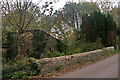
Horsepool Farm
A derelict farm on the southern edge of Godolphin Cross.
Image: © Ian Capper
Taken: 23 Oct 2011
0.12 miles
3
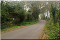
Into Godolphin Cross
The lane leading into Godolphin Cross from the south. On the left is Horsepool Chute (see Image and Image).
Image: © Ian Capper
Taken: 23 Oct 2011
0.12 miles
4
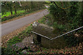
Horsepool Chute
Former village pump dating from the 19th century. For context see Image The opening on the side was for filling buckets. Grade II listed - see www.historicengland.org.uk/listing/the-list/list-entry/1328336.
Image: © Ian Capper
Taken: 23 Oct 2011
0.13 miles
5
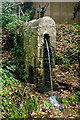
Horsepool Chute
Former village pump dating from the 19th century. For context see Image The pump metalwork was formerly where the water is spouting from. There is also a separate opening on the side for filling buckets - see Image Grade II listed - see www.historicengland.org.uk/listing/the-list/list-entry/1328336.
Image: © Ian Capper
Taken: 23 Oct 2011
0.13 miles
6
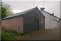
Godolphin Men's Institute
A wood/corrugated iron hall outside Godolphin Cross.
Image: © Ian Capper
Taken: 23 Oct 2011
0.14 miles
7
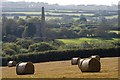
Polrose engine house
I stood in the field entrance and used the telephoto end of my zoom lens to frame the engine house with the bales in the field in front of it. According to Stephen Polglase's thoroughly researched and well-illustrated "Book of Breage and Germoe: the heart of the Godolphin tin dynasty" this engine house held a 40-inch cylinder steam engine and it ceased work in 1885.
Image: © Elizabeth Scott
Taken: 1 Oct 2011
0.14 miles
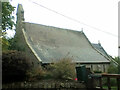
9
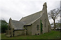
Former Church of St John the Baptist, Godolphin Cross
Built in 1850, but now redundant, since 1998. Grade II listed - see www.historicengland.org.uk/listing/the-list/list-entry/1142225.
For close up of cross seen in centre of photo, see Image
Image: © Ian Capper
Taken: 23 Oct 2011
0.15 miles
10
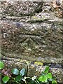
Benchmark Godolphin Parish Church
Benchmark description https://www.bench-marks.org.uk/bm147843
Image: © OfficeOfPudseyBMs
Taken: 25 May 2021
0.15 miles