IMAGES TAKEN NEAR TO
Breage, HELSTON, TR13 9PN
Introduction
This page details the photographs taken nearby to TR13 9PN by members of the Geograph project.
The Geograph project started in 2005 with the aim of publishing, organising and preserving representative images for every square kilometre of Great Britain, Ireland and the Isle of Man.

There are currently over 7.5m images from over14,400 individuals and you can help contribute to the project by visiting https://www.geograph.org.uk
Image Map
Images are licensed for reuse under creativecommons.org/licenses/by-sa/2.0
Notes
- Clicking on the map will re-center to the selected point.
- The higher the marker number, the further away the image location is from the centre of the postcode.
Image Listing (13 Images Found)
Images are licensed for reuse under creativecommons.org/licenses/by-sa/2.0
Image
Details
Distance
1
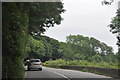
Cornwall : The A394
Looking along the A394 as it heads through Cornwall.
Image: © Lewis Clarke
Taken: 16 Jul 2015
0.11 miles
2
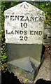
Old Milestone by the A394, south east of Breage - east face
Carved stone post by the A394, in parish of BREAGE (KERRIER District), Penbro, East of Breage, on bend, opposite steep drive in woods, on South side of road. Helston facets, erected by the Helston turnpike trust in the 19th century.
Inscription reads:-
: PENZANCE / 10 / LANDS END / 20 : : HELSTON / 3 / FALMOUTH / 15 :
Carved benchmark and rivet on top of East face.
Grade II listed.
List Entry Number: 1157986 https://historicengland.org.uk/listing/the-list/list-entry/1157986
Milestone Society National ID: CW_PZHL10.
Image: © Rosy Hanns
Taken: 26 Jul 2019
0.13 miles
3
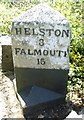
Old Milestone by the A394 south east of Breage - west face
Carved stone post by the A394, in parish of BREAGE (KERRIER District), Penbro, East of Breage, on bend, opposite steep drive in woods, on South side of road. Helston facets, erected by the Helston turnpike trust in the 19th century.
Inscription reads:-
: PENZANCE / 10 / LANDS END / 20 : : HELSTON / 3 / FALMOUTH / 15 :
Carved benchmark and rivet on top of East face.
Grade II listed.
List Entry Number: 1157986 https://historicengland.org.uk/listing/the-list/list-entry/1157986
Milestone Society National ID: CW_PZHL10.
Image: © Rosy Hanns
Taken: 26 Jul 2019
0.13 miles
4
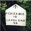
Old Milestone by the A394, south east of Breage
Carved stone post by the A394, in parish of BREAGE (KERRIER District), Penbro, East of Breage, on bend, opposite steep drive in woods, on South side of road. Helston facets, erected by the Helston turnpike trust in the 19th century.
Inscription reads:-
: PENZANCE / 10 / LANDS END / 20 : : HELSTON / 3 / FALMOUTH / 13 :
Carved benchmark on top of front face.
Grade II Listed. List Entry Number: 1157986
https://historicengland.org.uk/listing/the-list/list-entry/1157986
Milestone Society National ID: CW_PZHL10.
Image: © Ian Thompson
Taken: 10 Dec 2017
0.14 miles
5
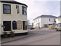
Side of Queen's Arms public house, Breage
Image: © nick macneill
Taken: 4 Apr 2011
0.19 miles
6
Barley Field near Breage
Barley field from public footpath between Breage and Porthleven
Image: © Roddy Urquhart
Taken: 26 Jul 2008
0.24 miles
7
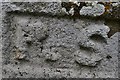
Breage: St. Breaca's Church: Carved initials near the south churchyard gate
Image: © Michael Garlick
Taken: 25 Sep 2015
0.24 miles
8
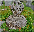
Breage: St. Breaca's Church: The four holed wheel cross
This could be c9th and is the oldest item in the church. Saxons did not have the tools to carve granite; this is made from red sandstone not found in the locality.
Image: © Michael Garlick
Taken: 25 Sep 2015
0.24 miles
9

Cornish Cross near the door of Breage Church.
Lovely Cross , the Church yard is circular usually meaning great age.
Image: © Michael Murray
Taken: 14 Jun 2006
0.25 miles