IMAGES TAKEN NEAR TO
Carnmeal, HELSTON, TR13 9NL
Introduction
This page details the photographs taken nearby to Carnmeal, TR13 9NL by members of the Geograph project.
The Geograph project started in 2005 with the aim of publishing, organising and preserving representative images for every square kilometre of Great Britain, Ireland and the Isle of Man.

There are currently over 7.5m images from over14,400 individuals and you can help contribute to the project by visiting https://www.geograph.org.uk
Image Map (4 Images)


Getting Data...Please wait
Leaflet Map data © OpenStreetMap
Images are licensed for reuse under creativecommons.org/licenses/by-sa/2.0
Notes
- Clicking on the map will re-center to the selected point.
- The higher the marker number, the further away the image location is from the centre of the postcode.
Image Listing (4 Images Found)
Images are licensed for reuse under creativecommons.org/licenses/by-sa/2.0
Image
Details
Distance
1
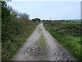
Mine track on Carnmeal Downs
The access track to the long-closed Carnmeal and Wheal Fortune mines, the spoil heaps of which are still in evidence on the landscape here.
Image: © Richard Law
Taken: 11 Oct 2015
0.19 miles
2
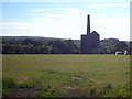
Engine house at Ivey's Shaft Pulldown
An unusually large engine house. In 1859 the building was fitted with an 1846 Harvey 85" engine, moved from Wheal Vor Trelawney's Shaft, and it is said that the engine house was also moved stone by stone. It has been suggested that this event was the origin of the name 'Pulldown'. Grade II Listed http://www.britishlistedbuildings.co.uk/en-65729-engine-house-at-sw628298-ivey-s-shaft-whe
Image: © Rod Allday
Taken: 3 Jun 2013
0.22 miles
3
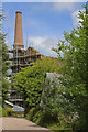
Engine House- Great Wheal Vor (Wheal Metal)
This is the best view from the public road and not involving trespass. It is nice to see consolidation in progress. This finely proportioned engine house is listed Grade II and housed a 85" Cornish beam pumping engine on Ivey's Shaft of the Wheal Metal section of this rich and venerable tin mine. The engine was built in 1855, transferred here in 1864 and removed to the Newcastle & Gateshead Water Company's site at Wylam in c1880. It survived into the 1940s.
Image: © Chris Allen
Taken: 21 May 2017
0.22 miles
4
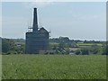
Wheal Vor engine house and chimney
See http://www.geograph.org.uk/photo/5414933 for a closer view and more information.
Image: © Robin Drayton
Taken: 16 Jun 2017
0.22 miles