IMAGES TAKEN NEAR TO
Breage, HELSTON, TR13 9NF
Introduction
This page details the photographs taken nearby to TR13 9NF by members of the Geograph project.
The Geograph project started in 2005 with the aim of publishing, organising and preserving representative images for every square kilometre of Great Britain, Ireland and the Isle of Man.

There are currently over 7.5m images from over14,400 individuals and you can help contribute to the project by visiting https://www.geograph.org.uk
Image Map
Images are licensed for reuse under creativecommons.org/licenses/by-sa/2.0
Notes
- Clicking on the map will re-center to the selected point.
- The higher the marker number, the further away the image location is from the centre of the postcode.
Image Listing (7 Images Found)
Images are licensed for reuse under creativecommons.org/licenses/by-sa/2.0
Image
Details
Distance
1
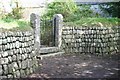
The Gate and Wall
A nice gate - walk from Tresoweshill to Trew
Image: © Ken Ballinger
Taken: 12 Sep 2005
0.08 miles
2
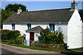
Tremelyon cottage
Another attractive cottage in Trew - TREMELYON
Image: © Ken Ballinger
Taken: 12 Sep 2005
0.08 miles
3
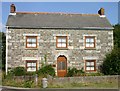
Trelawney House
Trelawney - a nice house in Trew.
Image: © Ken Ballinger
Taken: 12 Sep 2005
0.08 miles
4
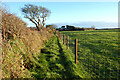
Pasture, Breage
A footpath follows the edge of fields beside Chynoweth Farm.
Image: © Andrew Smith
Taken: 2 Jan 2023
0.16 miles
5
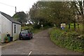
Lane to Treworlis Barton
Lane junction at the north end of Trew. Note the pre-Worboys "No Through Road" sign, and the helpful addition of a modern pictorial sign (albeit smaller than standard) for those who can't read.
Image: © Ian Capper
Taken: 25 Oct 2011
0.16 miles
6
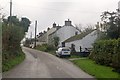
Trew
Row of cottages on the entrance to Trew from the north.
Image: © Ian Capper
Taken: 25 Oct 2011
0.18 miles
7
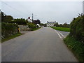
The southern side of Trew
A very rural place just north of Breage.
Image: © Richard Law
Taken: 11 Oct 2015
0.19 miles