IMAGES TAKEN NEAR TO
Shute Lane, HELSTON, TR13 9HY
Introduction
This page details the photographs taken nearby to Shute Lane, TR13 9HY by members of the Geograph project.
The Geograph project started in 2005 with the aim of publishing, organising and preserving representative images for every square kilometre of Great Britain, Ireland and the Isle of Man.

There are currently over 7.5m images from over14,400 individuals and you can help contribute to the project by visiting https://www.geograph.org.uk
Image Map
Images are licensed for reuse under creativecommons.org/licenses/by-sa/2.0
Notes
- Clicking on the map will re-center to the selected point.
- The higher the marker number, the further away the image location is from the centre of the postcode.
Image Listing (270 Images Found)
Images are licensed for reuse under creativecommons.org/licenses/by-sa/2.0
Image
Details
Distance
1
Porthleven: The Gue
The Gue is a road which runs from its junction with Fore Street, from which this photograph was taken, up to the southeast to join Peverell Road at another T-junction.
Image: © Dr Neil Clifton
Taken: 22 Apr 2010
0.03 miles
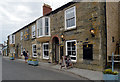
4

The Harbour Inn
Overlooking the inner Harbour one of two public houses at Porthleven Harbour.
Image: © Raymond Cubberley
Taken: 24 Jun 2012
0.04 miles
5
Porthleven: Fore Street
Looking southwest, towards the harbour
Image: © Dr Neil Clifton
Taken: 22 Apr 2010
0.05 miles

7

Ahead is Shute Lane
Harbour Road on the Right, Fore Street on the left in Porthleven
Image: © Raymond Cubberley
Taken: 24 Jun 2012
0.05 miles
9
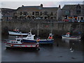
Porthleven Harbour at dusk
Taken at 8.30pm, just as the harbour lights came on.
Image: © Sharon Palmer
Taken: 13 Aug 2008
0.05 miles
10
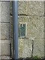
OS Flush Bracket - Porthleven
Flush Bracket S1476, set into the wall of the Customs House Art Gallery, which as the name implies was originally the local Customs House, and also the Harbour Master's house. The bracket was levelled in 1972 at 6.833m above Ordnance Datum Newlyn.
Image: © Richard Law
Taken: 13 Oct 2015
0.05 miles