IMAGES TAKEN NEAR TO
St. Pirans Parc, HELSTON, TR13 9BD
Introduction
This page details the photographs taken nearby to St. Pirans Parc, TR13 9BD by members of the Geograph project.
The Geograph project started in 2005 with the aim of publishing, organising and preserving representative images for every square kilometre of Great Britain, Ireland and the Isle of Man.

There are currently over 7.5m images from over14,400 individuals and you can help contribute to the project by visiting https://www.geograph.org.uk
Image Map (Loading...)


Getting Data...Please wait
Leaflet Map data © OpenStreetMap
Images are licensed for reuse under creativecommons.org/licenses/by-sa/2.0
Notes
- Clicking on the map will re-center to the selected point.
- The higher the marker number, the further away the image location is from the centre of the postcode.
Image Listing (190 Images Found)
Images are licensed for reuse under creativecommons.org/licenses/by-sa/2.0
Image
Details
Distance
1
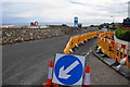
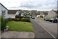
New housing development on the edge of Porthleven
These were arable fields before the development started. The development will be known as The Shrubberies as it is on Shrubberies Hill.
Image: © Bill Boaden
Taken: 7 Jul 2014
0.06 miles
2
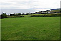
Horseshoe Playing Field
Recreational green space above Porthleven. The football pitch is on a slope which could prove challenging.
Image: © Bill Boaden
Taken: 7 Jul 2014
0.11 miles
4
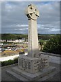
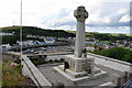
Porthleven war memorial
Porthleven war memorial stands on the side of Peverell Terrace overlooking the sea and the harbour below. Here it is pictured early on a late September morning with the low sun not yet fully lighting the cross.
Image: © Philip Halling
Taken: 26 Sep 2010
0.16 miles
5
Wheal Rose, Porthleven
Part of the housing estates climbing the hillside above Porthleven.
Image: © Bill Boaden
Taken: 7 Jul 2014
0.16 miles
6
War memorial at Porthleven
It is situated slightly away from the busiest areas but in a position overlooking the harbour.
Image: © Bill Boaden
Taken: 7 Jul 2014
0.17 miles
7
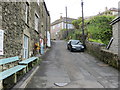
Salt Cellar Road in Porthleven
Looking eastward.
Image: © Peter Wood
Taken: 30 Apr 2017
0.17 miles
9
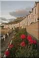
Bay View Terrace
A line of uniform Edwardian houses overlooking Porthleven harbour, seen in evening light. Grade II listed - for listing particulars see www.historicengland.org.uk/listing/the-list/list-entry/1196354.
Image: © Ian Capper
Taken: 28 Oct 2011
0.18 miles
10
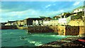
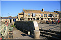
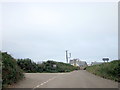
Porthleven harbour
NNE view from Harbour Road
Image: © Brian Ashworth32090
Taken: 24 Jul 2008
0.18 miles