IMAGES TAKEN NEAR TO
Church Hill, HELSTON, TR13 8TJ
Introduction
This page details the photographs taken nearby to Church Hill, TR13 8TJ by members of the Geograph project.
The Geograph project started in 2005 with the aim of publishing, organising and preserving representative images for every square kilometre of Great Britain, Ireland and the Isle of Man.

There are currently over 7.5m images from over14,400 individuals and you can help contribute to the project by visiting https://www.geograph.org.uk
Image Map (Loading...)


Getting Data...Please wait
Leaflet Map data © OpenStreetMap
Images are licensed for reuse under creativecommons.org/licenses/by-sa/2.0
Notes
- Clicking on the map will re-center to the selected point.
- The higher the marker number, the further away the image location is from the centre of the postcode.
Image Listing (3 Images Found)
Images are licensed for reuse under creativecommons.org/licenses/by-sa/2.0
Image
Details
Distance
1
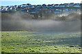
Pasture, woodland and houses, Helston
With slight frost and shallow mist in the valley of the River Cober.
Image: © Andrew Smith
Taken: 2 Jan 2023
0.21 miles
2
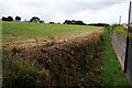
Footpath past Helston School
Most people find it easier to walk on top of the bank.
Image: © Bill Boaden
Taken: 10 Jul 2014
0.24 miles
3
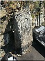
Old Boundary Marker on Church Hill, Helston
Municipal Boundary Marker against a stone wall next to Gwealhellis Cottage, on the north side of Church Hill. Inscribed HB, for Helston Borough; the letters are linked. On the former boundary of Helston and Wendron parishes but since 1934 entirely in Helston.
Milestone Society National ID: CW_HELWEN04pb
Image: © P Barnett
Taken: 26 Jun 2024
0.25 miles