IMAGES TAKEN NEAR TO
Lady Street, HELSTON, TR13 8NA
Introduction
This page details the photographs taken nearby to Lady Street, TR13 8NA by members of the Geograph project.
The Geograph project started in 2005 with the aim of publishing, organising and preserving representative images for every square kilometre of Great Britain, Ireland and the Isle of Man.

There are currently over 7.5m images from over14,400 individuals and you can help contribute to the project by visiting https://www.geograph.org.uk
Image Map (Loading...)


Getting Data...Please wait
Leaflet Map data © OpenStreetMap
Images are licensed for reuse under creativecommons.org/licenses/by-sa/2.0
Notes
- Clicking on the map will re-center to the selected point.
- The higher the marker number, the further away the image location is from the centre of the postcode.
Image Listing (210 Images Found)
Images are licensed for reuse under creativecommons.org/licenses/by-sa/2.0
Image
Details
Distance
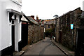
3
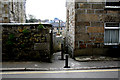
Helston: Tanyard Lane
Seen from Cross Street, this very narrow lane leads to the lower part of the town.
Image: © Dr Neil Clifton
Taken: 20 Apr 2010
0.04 miles
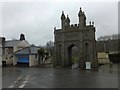
4
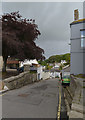
Helston: Palmshouse Hill
Looking north from its junction with Coinagehall Street.
Image: © Dr Neil Clifton
Taken: 20 Apr 2010
0.04 miles
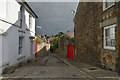
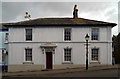
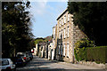
5
Helston: Lady Street
Off the north side of Coinagehall Street.
Image: © Dr Neil Clifton
Taken: 20 Apr 2010
0.04 miles
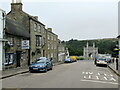
7
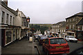
Helston - Coinagehall Street (2000)
Note the Woolworths on the right.
Image: © Colin Park
Taken: 27 Jul 2000
0.05 miles
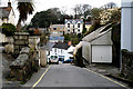
9
Helston: Cross Street
This pleasant street leads off the west side of Church Street
Image: © Dr Neil Clifton
Taken: 20 Apr 2010
0.05 miles
10
The Blue Anchor pub on Coinagehall Street Helston
Image: © Roy Hughes
Taken: 28 Jun 2023
0.05 miles