IMAGES TAKEN NEAR TO
Gweal Folds, Redruth Road, HELSTON, TR13 8LN
Introduction
This page details the photographs taken nearby to Gweal Folds, Redruth Road, TR13 8LN by members of the Geograph project.
The Geograph project started in 2005 with the aim of publishing, organising and preserving representative images for every square kilometre of Great Britain, Ireland and the Isle of Man.

There are currently over 7.5m images from over14,400 individuals and you can help contribute to the project by visiting https://www.geograph.org.uk
Image Map (Loading...)


Getting Data...Please wait
Leaflet Map data © OpenStreetMap
Images are licensed for reuse under creativecommons.org/licenses/by-sa/2.0
Notes
- Clicking on the map will re-center to the selected point.
- The higher the marker number, the further away the image location is from the centre of the postcode.
Image Listing (7 Images Found)
Images are licensed for reuse under creativecommons.org/licenses/by-sa/2.0
Image
Details
Distance
1
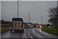
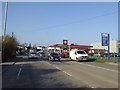
Helston : Redruth Road B3297
Looking along Redruth Road.
Image: © Lewis Clarke
Taken: 18 Dec 2019
0.09 miles
2
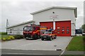
Helston Fire Station
Helston Fire Station, Redruth Road, Helston, Cornwall. One of a standard pattern Private Finance Initiative (PFI) scheme fire stations built in Cornwall recently, seen with its Mercedes Water Ladder and Vauxhall Brava Light 4 wheel drive Pump fire appliances.
Image: © Kevin Hale
Taken: 20 May 2006
0.18 miles
3
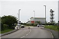
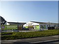
Road Junction and Fire Station
A modern fire station built in this industrial area on the north side of Helston.
Image: © Tony Atkin
Taken: 20 May 2006
0.21 miles
4
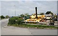
Tanks!
This collection of rather large army surplus was seen in the car park of a company on an industrial estate in the northern quarter of Helston.
Image: © Tony Atkin
Taken: 20 May 2006
0.22 miles
5
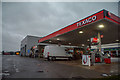
Helston : Texaco Petrol Station
A Texaco petrol station on Falmouth Road.
Image: © Lewis Clarke
Taken: 18 Dec 2019
0.23 miles
7
Texaco filling station by A394, Helston
Image: © David Smith
Taken: 14 Mar 2016
0.25 miles