IMAGES TAKEN NEAR TO
Meneage Road, HELSTON, TR13 8BH
Introduction
This page details the photographs taken nearby to Meneage Road, TR13 8BH by members of the Geograph project.
The Geograph project started in 2005 with the aim of publishing, organising and preserving representative images for every square kilometre of Great Britain, Ireland and the Isle of Man.

There are currently over 7.5m images from over14,400 individuals and you can help contribute to the project by visiting https://www.geograph.org.uk
Image Map (Loading...)


Getting Data...Please wait
Leaflet Map data © OpenStreetMap
Images are licensed for reuse under creativecommons.org/licenses/by-sa/2.0
Notes
- Clicking on the map will re-center to the selected point.
- The higher the marker number, the further away the image location is from the centre of the postcode.
Image Listing (26 Images Found)
Images are licensed for reuse under creativecommons.org/licenses/by-sa/2.0
Image
Details
Distance
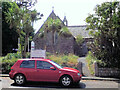
4
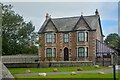
Helston : House
A house seen from Meneage Road.
Image: © Lewis Clarke
Taken: 1 Oct 2022
0.09 miles
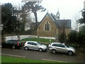
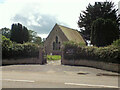
5
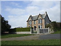
Victorian House in Helston
The original owners of this house probably enjoyed splendid isolation off the Lizard road south of Helston. It has now been surrounded by housing as a result of the expansion of the Culdrose air base.
Image: © Jonathan Billinger
Taken: 14 Mar 2007
0.10 miles
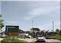
9
A394 approaching roundabout
Looking south east.
Image: © JThomas
Taken: 12 Jul 2017
0.16 miles