IMAGES TAKEN NEAR TO
Sithney, HELSTON, TR13 0RT
Introduction
This page details the photographs taken nearby to TR13 0RT by members of the Geograph project.
The Geograph project started in 2005 with the aim of publishing, organising and preserving representative images for every square kilometre of Great Britain, Ireland and the Isle of Man.

There are currently over 7.5m images from over14,400 individuals and you can help contribute to the project by visiting https://www.geograph.org.uk
Image Map
Images are licensed for reuse under creativecommons.org/licenses/by-sa/2.0
Notes
- Clicking on the map will re-center to the selected point.
- The higher the marker number, the further away the image location is from the centre of the postcode.
Image Listing (7 Images Found)
Images are licensed for reuse under creativecommons.org/licenses/by-sa/2.0
Image
Details
Distance
1
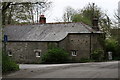
Mill Farm
House at Mill Farm at the junction of the minor road to Tregoose.
Image: © Elizabeth Scott
Taken: 16 Apr 2011
0.01 miles
2
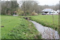
Stream at Sithney Green
Seen here running through a large private garden, the stream runs into the River Cober below Lowertown.
Image: © Rod Allday
Taken: 30 Mar 2011
0.06 miles
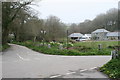
4
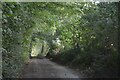
Sithney : Road
A road heading through the countryside.
Image: © Lewis Clarke
Taken: 29 Sep 2022
0.08 miles
5
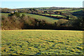
Sithney Green
Looking down into the wooded valley from the west.
Image: © Tony Atkin
Taken: 18 Feb 2006
0.10 miles
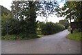
6
Sithney : Road
A road heading through the countryside.
Image: © Lewis Clarke
Taken: 29 Sep 2022
0.13 miles
7
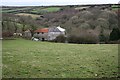
Pasture, Sithney
Seen from a footpath above Sithney Green, Tregoose is seen across the valley.
Image: © Andrew Smith
Taken: 2 Jan 2023
0.18 miles