IMAGES TAKEN NEAR TO
Coverack Bridges, HELSTON, TR13 0PB
Introduction
This page details the photographs taken nearby to TR13 0PB by members of the Geograph project.
The Geograph project started in 2005 with the aim of publishing, organising and preserving representative images for every square kilometre of Great Britain, Ireland and the Isle of Man.

There are currently over 7.5m images from over14,400 individuals and you can help contribute to the project by visiting https://www.geograph.org.uk
Image Map
Images are licensed for reuse under creativecommons.org/licenses/by-sa/2.0
Notes
- Clicking on the map will re-center to the selected point.
- The higher the marker number, the further away the image location is from the centre of the postcode.
Image Listing (8 Images Found)
Images are licensed for reuse under creativecommons.org/licenses/by-sa/2.0
Image
Details
Distance
1
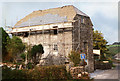
Sithney: Boscadjack Mill
Undergoing a house conversion in 1996
Image: © Martin Bodman
Taken: Unknown
0.04 miles
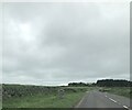
2
Modern marker by B3297
The stone on the left announces that this is Wendron District, part of the Cornish Mining region
Image: © David Smith
Taken: 14 Mar 2016
0.15 miles
3
Modern boundary stone entering Wendron District
Image: © Paul Barnett
Taken: 1 Apr 2023
0.16 miles
4
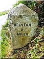
Old Milestone by the B3297, south west of Tregarthen
Carved stone post by the B3297, in parish of WENDRON (KERRIER District), just South of older milestone, buried in bank, on West side of road. Erected by the Local Highways Board in the 19th century.
Inscription reads:-
: REDRUTH / 8 / MILES : : HELSTON / 2 / MILES :
Grade II Listed. List Entry Number: 1328453
https://historicengland.org.uk/listing/the-list/list-entry/1328453
Milestone Society National ID: CW_RRHL08.
Milestone Society National ID: CW_HLLE02 is nearby Image
Image: © Ian Thompson
Taken: 10 Dec 2017
0.20 miles
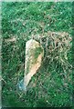
5
Old Milestone by the B3297, south west of Tregarthen
Carved stone post by the B3297, in parish of WENDRON (KERRIER District), buried in bank, on West side of road. Erected by the Local Highways Board in the 19th century. Just South of older milestone: CW_HLLE02 Image
Inscription reads:-
: REDRUTH / 8 / MILES : : HELSTON / 2 / MILES :
Grade II listed.
List Entry Number: 1328453 https://historicengland.org.uk/listing/the-list/list-entry/1328453
Milestone Society National ID: CW_RRHL08.
Image: © Rosy Hanns
Taken: 30 May 2019
0.20 miles
6
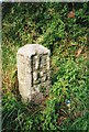
Old Milestone by the B3297, south west of Tregarthen
Carved stone post by the B3297, in parish of WENDRON (KERRIER District), Tregarthen, on the verge, on West side of road. Erected by the parish in the 18th century.
Inscription reads:-
: H / 2 : : L / 25 :
(To Helston and Lands End)
Grade II Listed. List Entry Number: 1142011
https://historicengland.org.uk/listing/the-list/list-entry/1142011
Milestone Society National ID: CW_HLLE02.
Image: © Ian Thompson
Taken: 10 Dec 2017
0.20 miles
7
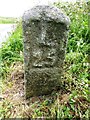
Old Milestone by the B3297, south west of Tregarthen
Carved stone post by the B3297, in parish of WENDRON (KERRIER District), Tregarthen, on the verge, on West side of road. Erected by the parish in the 18th century. Opposite field gate and just North East of newer milestone: CW_RRHL08 Image
Inscription reads:-
: H / 2 : : L / 25 :
(To Helston and Land's End)
Carved benchmark on lower 'H' face.
Grade II Listed.
List Entry Number: 1142011 https://historicengland.org.uk/listing/the-list/list-entry/1142011
Milestone Society National ID: CW_HLLE02.
Image: © Rosy Hanns
Taken: 30 May 2019
0.21 miles
8
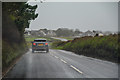
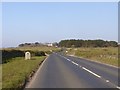
Wendron : Redruth Road B3297
Looking along Redruth Road through the parish of Wendron.
Image: © Lewis Clarke
Taken: 18 Dec 2019
0.22 miles