IMAGES TAKEN NEAR TO
Wendron, HELSTON, TR13 0NL
Introduction
This page details the photographs taken nearby to TR13 0NL by members of the Geograph project.
The Geograph project started in 2005 with the aim of publishing, organising and preserving representative images for every square kilometre of Great Britain, Ireland and the Isle of Man.

There are currently over 7.5m images from over14,400 individuals and you can help contribute to the project by visiting https://www.geograph.org.uk
Image Map
Images are licensed for reuse under creativecommons.org/licenses/by-sa/2.0
Notes
- Clicking on the map will re-center to the selected point.
- The higher the marker number, the further away the image location is from the centre of the postcode.
Image Listing (11 Images Found)
Images are licensed for reuse under creativecommons.org/licenses/by-sa/2.0
Image
Details
Distance
1
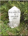
Old Milestone by the A394, Wheal Lovell Farm
Carved stone post by the A394, in parish of WENDRON (KERRIER District), Wheal Lovell Farm, just North of Manhay, reset (May 98), on East side of road. Helston facets, erected by the Helston turnpike trust in the 19th century.
Inscription reads:-
: HELSTON / 3 / PENZANCE / 16 : : FALMOUTH / 9 / TRURO / 13¾ :
Grade II Listed. List Entry Number: 1141992
https://historicengland.org.uk/listing/the-list/list-entry/1141992
Milestone Society National ID: CW_PZTO16
Image: © Milestone Society
Taken: Unknown
0.01 miles
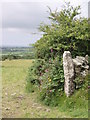
2
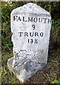
Old Milestone by the A394, Wheal Lovell Farm
Carved stone post by the A394, in parish of WENDRON (KERRIER District), Wheal Lovell Farm, just North of Manhay, reset (May 98), on East side of road. Helston facets, erected by the Helston turnpike trust in the 19th century.
Inscription reads:-
: HELSTON / 3 / PENZANCE / 16 : : FALMOUTH / 9 / TRURO / 13¾ :
Grade II listed.
List Entry Number: 1141992 https://historicengland.org.uk/listing/the-list/list-entry/1141992
Milestone Society National ID: CW_PZTO16.
Image: © Rosy Hanns
Taken: 27 Jul 2019
0.01 miles
3
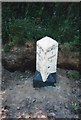
Old Milestone by the A394, Wheal Lovell Farm
Carved stone post by the A394, in parish of WENDRON (KERRIER District), Wheal Lovell Farm, just North of Manhay, reset (May 98), on East side of road. Helston facets, erected by the Helston turnpike trust in the 19th century.
Inscription reads:-
: HELSTON / 3 / PENZANCE / 16 : : FALMOUTH / 9 / TRURO / 13¾ :
Grade II Listed. List Entry Number: 1141992
https://historicengland.org.uk/listing/the-list/list-entry/1141992
Milestone Society National ID: CW_PZTO16.
Image: © Ian Thompson
Taken: 23 May 1998
0.02 miles
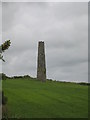
4
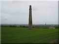
Isolated chimney in a field at Manhay
This chimney and the other in the same field appear to have been associated with East Wheal Lovell Mine.
Image: © Rod Allday
Taken: 4 Jun 2008
0.06 miles
5
Isolated chimney in a field at Manhay
This chimney and the other in the same field appear to have been associated with East Wheal Lovell Mine.
Image: © Rod Allday
Taken: 4 Jun 2008
0.06 miles
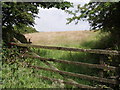
9
View from Manhay Beacon
Looking south west towards Helston.
Image: © Sheila Russell
Taken: 28 Jun 2006
0.17 miles
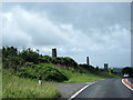
10

Pasture. Wendron
The relatively short chimney of Beacon Hill Mine is seen in the background.
Image: © Andrew Smith
Taken: 26 Dec 2022
0.22 miles