IMAGES TAKEN NEAR TO
Coverack Bridges, HELSTON, TR13 0LX
Introduction
This page details the photographs taken nearby to TR13 0LX by members of the Geograph project.
The Geograph project started in 2005 with the aim of publishing, organising and preserving representative images for every square kilometre of Great Britain, Ireland and the Isle of Man.

There are currently over 7.5m images from over14,400 individuals and you can help contribute to the project by visiting https://www.geograph.org.uk
Image Map
Images are licensed for reuse under creativecommons.org/licenses/by-sa/2.0
Notes
- Clicking on the map will re-center to the selected point.
- The higher the marker number, the further away the image location is from the centre of the postcode.
Image Listing (9 Images Found)
Images are licensed for reuse under creativecommons.org/licenses/by-sa/2.0
Image
Details
Distance
3
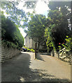
Valley Bottom at Coverack Bridges
This is the valley of the River Cober.
Image: © Tony Atkin
Taken: 20 May 2006
0.04 miles
4
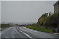
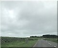
Wendron : Redruth Road B3297
Looking along Redruth Road through the parish of Wendron.
Image: © Lewis Clarke
Taken: 18 Dec 2019
0.16 miles
6
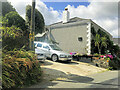
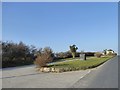
Modern boundary stone entering Wendron District
Image: © Paul Barnett
Taken: 1 Apr 2023
0.20 miles
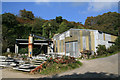
7
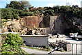
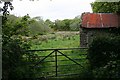
Trannack Quarry
This site appears to be split either side of a stream. This part was behind secure fencing. Some years ago there was a dismantled compressed air powered derrick crane somewhere on this site. I was unable to verify its continued existence on a Sunday afternoon with the site locked and nobody to ask.
Image: © Chris Allen
Taken: 21 Sep 2008
0.21 miles
8
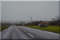
Wendron : Redruth Road B3297
Looking along Redruth Road through the parish of Wendron.
Image: © Lewis Clarke
Taken: 18 Dec 2019
0.22 miles
9
Trannack Quarry
Used by a firm of monumental masons.
Image: © Chris Allen
Taken: 21 Sep 2008
0.23 miles