IMAGES TAKEN NEAR TO
Porkellis, HELSTON, TR13 0HX
Introduction
This page details the photographs taken nearby to TR13 0HX by members of the Geograph project.
The Geograph project started in 2005 with the aim of publishing, organising and preserving representative images for every square kilometre of Great Britain, Ireland and the Isle of Man.

There are currently over 7.5m images from over14,400 individuals and you can help contribute to the project by visiting https://www.geograph.org.uk
Image Map
Images are licensed for reuse under creativecommons.org/licenses/by-sa/2.0
Notes
- Clicking on the map will re-center to the selected point.
- The higher the marker number, the further away the image location is from the centre of the postcode.
Image Listing (4 Images Found)
Images are licensed for reuse under creativecommons.org/licenses/by-sa/2.0
Image
Details
Distance
1
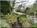
Stream by the drive
To a house at Calvadnack
Image: © Jonathan Billinger
Taken: 5 Mar 2008
0.07 miles
2
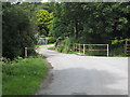
Bridge at Tolcarne-Wartha
Crossing a small tributary of the River Cober.
Image: © Rod Allday
Taken: 2 Aug 2008
0.07 miles
3
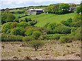
Heath, pasture and farm buildings, Wendron
Tolcarne Wartha viewed from the lower western slopes of Calvadnack.
Image: © Andrew Smith
Taken: 11 May 2019
0.08 miles
4
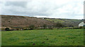
Pasture and moorland
The access land of Calvadnack stands out on the hillside.
Image: © Jonathan Billinger
Taken: 5 Mar 2008
0.19 miles