IMAGES TAKEN NEAR TO
Trenear, HELSTON, TR13 0HQ
Introduction
This page details the photographs taken nearby to TR13 0HQ by members of the Geograph project.
The Geograph project started in 2005 with the aim of publishing, organising and preserving representative images for every square kilometre of Great Britain, Ireland and the Isle of Man.

There are currently over 7.5m images from over14,400 individuals and you can help contribute to the project by visiting https://www.geograph.org.uk
Image Map
Images are licensed for reuse under creativecommons.org/licenses/by-sa/2.0
Notes
- Clicking on the map will re-center to the selected point.
- The higher the marker number, the further away the image location is from the centre of the postcode.
Image Listing (4 Images Found)
Images are licensed for reuse under creativecommons.org/licenses/by-sa/2.0
Image
Details
Distance
1
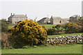
Higher Boscadjack
Farmhouse and buildings, Higher Boscadjack.
Image: © Elizabeth Scott
Taken: 9 Apr 2011
0.03 miles
2
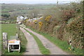
Access lane to Higher Boscadjack Farm
This is the access lane to Higher Boscadjack Farm.
Image: © Elizabeth Scott
Taken: 9 Apr 2011
0.09 miles
3
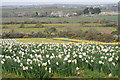
Daffodils at Higher Boscadjack
I stood at the field gate nearest to Higher Boscadjack Farm and took this shot showing the paler daffodils and the fields beyond.
Image: © Elizabeth Scott
Taken: 9 Apr 2011
0.15 miles
4
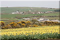
Daffodils and view to Wendron
From the field entrance I took this shot of these Soleil D'Or daffodils. In the distance, the village with the church is Wendron.
Image: © Elizabeth Scott
Taken: 9 Apr 2011
0.24 miles