IMAGES TAKEN NEAR TO
Trenear, HELSTON, TR13 0ET
Introduction
This page details the photographs taken nearby to TR13 0ET by members of the Geograph project.
The Geograph project started in 2005 with the aim of publishing, organising and preserving representative images for every square kilometre of Great Britain, Ireland and the Isle of Man.

There are currently over 7.5m images from over14,400 individuals and you can help contribute to the project by visiting https://www.geograph.org.uk
Image Map (Loading...)


Getting Data...Please wait
Leaflet Map data © OpenStreetMap
Images are licensed for reuse under creativecommons.org/licenses/by-sa/2.0
Notes
- Clicking on the map will re-center to the selected point.
- The higher the marker number, the further away the image location is from the centre of the postcode.
Image Listing (4 Images Found)
Images are licensed for reuse under creativecommons.org/licenses/by-sa/2.0
Image
Details
Distance
1
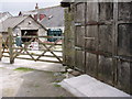
Discouraging sign
The walk down the lane was going well, until this sign...but...
Image: © Sheila Russell
Taken: 28 Jun 2006
0.13 miles
2
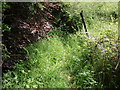
The lane continues
Much overgrown and just to the west of the discouraging sign the lane does continue.
Image: © Sheila Russell
Taken: 28 Jun 2006
0.19 miles
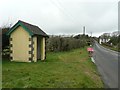
4
Bus shelter by B3297 near Crelly
At the junction for Crelly and Crelly Farm; why doesn't it have a window so passengers can watch for the approaching bus?
Image: © David Smith
Taken: 14 Mar 2016
0.24 miles