IMAGES TAKEN NEAR TO
Nancegollan, HELSTON, TR13 0AX
Introduction
This page details the photographs taken nearby to TR13 0AX by members of the Geograph project.
The Geograph project started in 2005 with the aim of publishing, organising and preserving representative images for every square kilometre of Great Britain, Ireland and the Isle of Man.

There are currently over 7.5m images from over14,400 individuals and you can help contribute to the project by visiting https://www.geograph.org.uk
Image Map
Images are licensed for reuse under creativecommons.org/licenses/by-sa/2.0
Notes
- Clicking on the map will re-center to the selected point.
- The higher the marker number, the further away the image location is from the centre of the postcode.
Image Listing (9 Images Found)
Images are licensed for reuse under creativecommons.org/licenses/by-sa/2.0
Image
Details
Distance
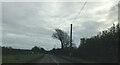
1
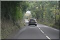
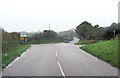
Breage : B3302
Looking along the B3302.
Image: © Lewis Clarke
Taken: 29 Sep 2022
0.11 miles
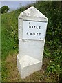
2
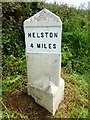
Old Milestone by the B3302, east of Huthnance - west face
Stone post (plate lost and replaced) by the B3302, in parish of BREAGE (KERRIER District), Huthnance, East of camp site, on the verge, set back from road, on East side of road. Erected by the Local Highways Board in the 19th century.
Inscription reads:-
: HELSTON / 4 MILES : : HAYLE / 6 MILES :
Cornwall & Scilly HER.
HER Number: 178372 https://www.heritagegateway.org.uk/Gateway/Results_Single.aspx?uid=MCO54149&resourceID=1020
Milestone Society National ID: CW_HLHY04.
Image: © Rosy Hanns
Taken: 31 May 2019
0.16 miles
3
Old Milestone by the B3302, east of Huthnance - east face
Stone post (plates lost and replaced) by the B3302, in parish of BREAGE (KERRIER District), Huthnance, East of camp site, on the verge, set back from road, on East side of road. Erected by the Local Highways Board in the 19th century.
Inscription reads:-
: HELSTON / 4 MILES : : HAYLE / 6 MILES :
Cornwall & Scilly HER.
HER Number: 178372 https://www.heritagegateway.org.uk/Gateway/Results_Single.aspx?uid=MCO54149&resourceID=1020
Milestone Society National ID: CW_HLHY04.
Image: © Rosy Hanns
Taken: 31 May 2019
0.16 miles
4
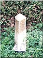
Old Milestone by the B3302, east of Huthnance
Stone post (plates lost) by the B3302, in parish of BREAGE (KERRIER District), Huthnance, East of camp site, on the verge, set back from road, on East side of road. Erected by the Local Highways Board in the 19th century.
Inscription reads:-
:plate missing (HELSTON / 4) : : plate missing (HAYLE / 6) :
Milestone Society National ID: CW_HLHY04.
Image: © Ian Thompson
Taken: 10 Dec 2017
0.16 miles
5
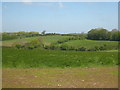
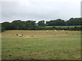
Fields at Lower Pengwedna
The B3302 runs behind the trees at the top of the photo.
Image: © Rod Allday
Taken: 30 May 2013
0.17 miles
6
Old Milestone by the B3302, east of Huthnance
Stone post (plates lost and replaced) by the B3302, in parish of BREAGE (KERRIER District), Huthnance, East of camp site, on the verge, set back from road, on East side of road. Erected by the Local Highways Board in the 19th century.
Inscription reads:-
HELSTON / 4 MILES : : HAYLE / 6 MILES
Cornwall & Scilly HER.
HER Number: 178372
Milestone Society National ID: CW_HLHY04
Image: © Paul Barnett
Taken: 22 Jan 2023
0.19 miles
7
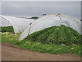
Strawberry plants in polytunnels
Just ripe, a deliciously sweet smell.
Image: © Sheila Russell
Taken: 27 Jun 2006
0.20 miles