IMAGES TAKEN NEAR TO
Gwarak An Warak, TRURO, TR1 2FP
Introduction
This page details the photographs taken nearby to Gwarak An Warak, TR1 2FP by members of the Geograph project.
The Geograph project started in 2005 with the aim of publishing, organising and preserving representative images for every square kilometre of Great Britain, Ireland and the Isle of Man.

There are currently over 7.5m images from over14,400 individuals and you can help contribute to the project by visiting https://www.geograph.org.uk
Image Map
Images are licensed for reuse under creativecommons.org/licenses/by-sa/2.0
Notes
- Clicking on the map will re-center to the selected point.
- The higher the marker number, the further away the image location is from the centre of the postcode.
Image Listing (27 Images Found)
Images are licensed for reuse under creativecommons.org/licenses/by-sa/2.0
Image
Details
Distance
1
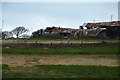
Cornwall : Grassy Field
A grassy field and a destroyed barn at Tolgarrick Farm.
Image: © Lewis Clarke
Taken: 19 Apr 2017
0.02 miles
2
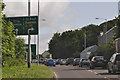
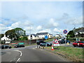
Truro : Arch Hill A39
Heading towards the roundabout and realising we are in the wrong lane to continue on the A39.
Image: © Lewis Clarke
Taken: 17 Jul 2015
0.03 miles
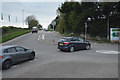
3
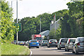
Truro : Arch Hill A39
Looking along Arch Hill as it heads into Truro.
Image: © Lewis Clarke
Taken: 17 Jul 2015
0.05 miles
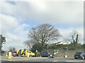
6
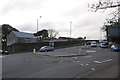
Ringroad junction, A39, A390, Falmouth Road
Image: © Roger Templeman
Taken: 12 Nov 2011
0.10 miles
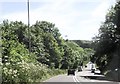
7
Truro : Green Lane A390
Looking along Green lane.
Image: © Lewis Clarke
Taken: 19 Apr 2017
0.10 miles
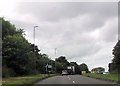
10

The A39
Approaching Tolgarrick Roundabout. The farm buildings in the background might be Calenick Farm
Image: © Robert Ashby
Taken: 21 Aug 2014
0.11 miles