
IMAGES TAKEN NEAR TO
Barrack Lane, TRURO, TR1 2DW
Introduction
This page details the photographs taken nearby to Barrack Lane, TR1 2DW by members of the Geograph project.
The Geograph project started in 2005 with the aim of publishing, organising and preserving representative images for every square kilometre of Great Britain, Ireland and the Isle of Man.

There are currently over 7.5m images from over14,400 individuals and you can help contribute to the project by visiting https://www.geograph.org.uk
Image Map
Images are licensed for reuse under creativecommons.org/licenses/by-sa/2.0
Notes
- Clicking on the map will re-center to the selected point.
- The higher the marker number, the further away the image location is from the centre of the postcode.
Image Listing (87 Images Found)
Images are licensed for reuse under creativecommons.org/licenses/by-sa/2.0
Image
Details
Distance
2

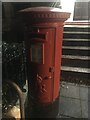
Strangways Terrace Truro
An early 19th century terrace overlooking the city of Truro; the steps from pavement to the road are unusual
Image: © David Smith
Taken: 1 Feb 2013
0.06 miles
3
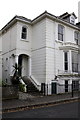
#4 Strangways Villas
At ground level at the railings junction is an OS benchmark Image
Image: © Roger Templeman
Taken: 12 Nov 2011
0.08 miles
4
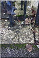
Benchmark at entrance to #4 Strangways Villas
Ordnance Survey rivet benchmark described on the Bench Mark Database at http://www.bench-marks.org.uk/bm40156
Image: © Roger Templeman
Taken: 12 Nov 2011
0.08 miles
6
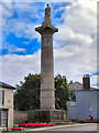
Richard Lander's Monument
The Richard Lander Monument is an impressive stone column at the top of Truro's Lemon Street. It was erected, in 1835, to celebrate the discoveries (including the source of River Niger in 1827) of the Lander brothers, Richard and John and in memory of Richard who died during an expedition1834.
The monument, sadly, is badly eroded. It was given Grade II listed status in 1950.
http://www.britishlistedbuildings.co.uk/en-377618-lander-s-monument-truro for details of its listed status.
Image: © David Dixon
Taken: 28 Jul 2010
0.08 miles
7

Monument to Richard Lander, Truro
At the top of Lemon Street, a monument to Richard Lemon Lander (1804-1834), a Truro-born explorer of western Africa.
Image: © David Weston
Taken: 25 Apr 2016
0.09 miles
8
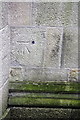
Benchmark on St Johns Church, Lemon Street
Ordnance Survey 1GL bolt benchmark described on the Bench Mark Database at http://www.bench-marks.org.uk/bm24776
Image: © Roger Templeman
Taken: 12 Nov 2011
0.09 miles
9
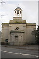
St Johns Church, Lemon Street
To the right of the semi-circular jut is an OS benchmark Image
Image: © Roger Templeman
Taken: 12 Nov 2011
0.09 miles
10
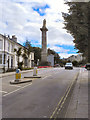
Lemon Street
The top of Lemon Street, before it becomes Falmouth Road. Image] is prominent on the left hand side of the road.
Image: © David Dixon
Taken: 28 Jul 2010
0.09 miles