IMAGES TAKEN NEAR TO
Cury Cross Lanes, HELSTON, TR12 7QX
Introduction
This page details the photographs taken nearby to TR12 7QX by members of the Geograph project.
The Geograph project started in 2005 with the aim of publishing, organising and preserving representative images for every square kilometre of Great Britain, Ireland and the Isle of Man.

There are currently over 7.5m images from over14,400 individuals and you can help contribute to the project by visiting https://www.geograph.org.uk
Image Map
Images are licensed for reuse under creativecommons.org/licenses/by-sa/2.0
Notes
- Clicking on the map will re-center to the selected point.
- The higher the marker number, the further away the image location is from the centre of the postcode.
Image Listing (7 Images Found)
Images are licensed for reuse under creativecommons.org/licenses/by-sa/2.0
Image
Details
Distance
1
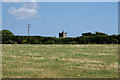
Field near Cury
A footpath from Sowanna Farm crosses this field. The tower of Cury Parish Church can be seen ahead.
Image: © Bill Boaden
Taken: 29 Jun 2014
0.22 miles
2
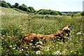
Cattle in the long grass
A number of young bullocks have found their way into the soggy land in the valley bottom.
Image: © Bill Boaden
Taken: 29 Jun 2014
0.23 miles
3
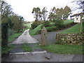
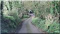
Road to Trevergy
A dairy farm proud of its herd.
Image: © Jonathan Billinger
Taken: 14 Mar 2007
0.23 miles
4
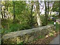
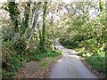
Woodland stream north of Cury
The parapet of a small bridge on a road north of Cury
Image: © David Smith
Taken: 30 Sep 2015
0.24 miles
5
Valley north of Cury
A small stream crossed by the minor road from Cury to Millewarne
Image: © David Smith
Taken: 30 Sep 2015
0.24 miles
6
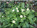
Wild Primrose
Primula vulgaris in all its understated glory on a Cornish roadside.
Image: © Jonathan Billinger
Taken: 14 Mar 2007
0.24 miles
7
Unnamed lane northeast of Sowanna Farm
The little brook at the bottom of this slope eventually flows into the sea at Church Cove.
Image: © Stuart Logan
Taken: 10 Oct 2012
0.24 miles