IMAGES TAKEN NEAR TO
Trewoon Road, HELSTON, TR12 7DT
Introduction
This page details the photographs taken nearby to Trewoon Road, TR12 7DT by members of the Geograph project.
The Geograph project started in 2005 with the aim of publishing, organising and preserving representative images for every square kilometre of Great Britain, Ireland and the Isle of Man.

There are currently over 7.5m images from over14,400 individuals and you can help contribute to the project by visiting https://www.geograph.org.uk
Image Map
Images are licensed for reuse under creativecommons.org/licenses/by-sa/2.0
Notes
- Clicking on the map will re-center to the selected point.
- The higher the marker number, the further away the image location is from the centre of the postcode.
Image Listing (3 Images Found)
Images are licensed for reuse under creativecommons.org/licenses/by-sa/2.0
Image
Details
Distance
1
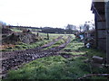
East from Chypons Road
These are fields north of Clahar Barton Farm.
Image: © Jonathan Billinger
Taken: 14 Mar 2007
0.12 miles
2
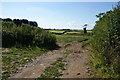
Field entrance near Trewoon
Much of the farmland appears to be sitting idly by, but once the silage has been collected there isn't much else to do. Newton Farm can be seen on the far hill.
Image: © Bill Boaden
Taken: 29 Jun 2014
0.19 miles
3
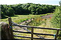
Former cattle pen near Clahar Garden Farm
The boundaries are secure, but the facilities do not look like they are in use.
Image: © Bill Boaden
Taken: 29 Jun 2014
0.19 miles