IMAGES TAKEN NEAR TO
Churchtown, HELSTON, TR12 7BY
Introduction
This page details the photographs taken nearby to Churchtown, TR12 7BY by members of the Geograph project.
The Geograph project started in 2005 with the aim of publishing, organising and preserving representative images for every square kilometre of Great Britain, Ireland and the Isle of Man.

There are currently over 7.5m images from over14,400 individuals and you can help contribute to the project by visiting https://www.geograph.org.uk
Image Map
Images are licensed for reuse under creativecommons.org/licenses/by-sa/2.0
Notes
- Clicking on the map will re-center to the selected point.
- The higher the marker number, the further away the image location is from the centre of the postcode.
Image Listing (127 Images Found)
Images are licensed for reuse under creativecommons.org/licenses/by-sa/2.0
Image
Details
Distance
1
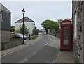
Churchtown
An old red telephone box can be seen in the foreground.
Image: © habiloid
Taken: 31 May 2019
0.01 miles
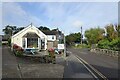
2
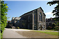
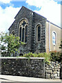
Mullion Methodist Church
Newer than the smaller Wesleyan Chapel over the road.
Image: © Bill Boaden
Taken: 29 Jun 2014
0.01 miles
3
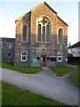
Mullion Methodist church
The building straddles a gridline; the path and facade in one square, the worship end in Image
Image: © David Smith
Taken: 28 Sep 2015
0.01 miles
5
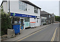
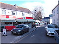
Boots pharmacy
The road running through the photo is Churchtown.
Image: © habiloid
Taken: 31 May 2019
0.02 miles
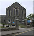
8
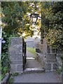
One gateway into the churchyard, Mullion
Image: © David Smith
Taken: 28 Sep 2015
0.02 miles
9
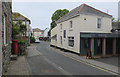
Mullion General Store
The narrow, one-way high street, typical of Cornish villages.
Image: © Jonathan Billinger
Taken: 14 Mar 2007
0.03 miles
10
Milk Barn Cafe
At the junction of Lender Lane and Churchtown in Mullion.
Image: © DS Pugh
Taken: 6 Sep 2024
0.03 miles