IMAGES TAKEN NEAR TO
Polcoverack Lane, HELSTON, TR12 6TD
Introduction
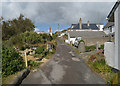
This page details the photographs taken nearby to Polcoverack Lane, TR12 6TD by members of the Geograph project.
The Geograph project started in 2005 with the aim of publishing, organising and preserving representative images for every square kilometre of Great Britain, Ireland and the Isle of Man.

There are currently over 7.5m images from over14,400 individuals and you can help contribute to the project by visiting https://www.geograph.org.uk
Image Map
Images are licensed for reuse under creativecommons.org/licenses/by-sa/2.0
Notes
- Clicking on the map will re-center to the selected point.
- The higher the marker number, the further away the image location is from the centre of the postcode.
Image Listing (73 Images Found)
Images are licensed for reuse under creativecommons.org/licenses/by-sa/2.0
Image
Details
Distance
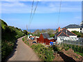
1
Track leading up to Polcoverack Farm
Image: © Dr Duncan Pepper
Taken: 8 Jul 2013
0.05 miles
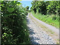
2
Wooded valley below Polcoverack Farm
Image: © Dr Duncan Pepper
Taken: 8 Jul 2013
0.05 miles
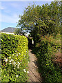
3
Path from Polecoverack Lane to Chymbloth Way, Coverack
Image: © habiloid
Taken: 31 May 2021
0.08 miles
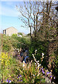
5
Path from Polecoverack Lane to Chymbloth Way, Coverack
Image: © habiloid
Taken: 31 May 2021
0.09 miles
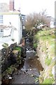
6
Stream running alongside Polecoverack Lane, Coverack
Image: © habiloid
Taken: 31 May 2021
0.12 miles
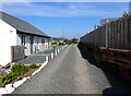
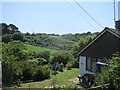
8
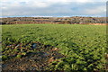
Open countryside just inland from Coverack
According to the OS map this field may be used as a camping and caravan site in the summer.
Image: © Philip Halling
Taken: 18 Feb 2006
0.16 miles
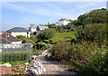
9
Stream at Coverack
At this point the stream runs under the road and across the beach to the sea.
Image: © Trevor Harris
Taken: 14 Apr 2009
0.18 miles