IMAGES TAKEN NEAR TO
St. Keverne, HELSTON, TR12 6RN
Introduction
This page details the photographs taken nearby to TR12 6RN by members of the Geograph project.
The Geograph project started in 2005 with the aim of publishing, organising and preserving representative images for every square kilometre of Great Britain, Ireland and the Isle of Man.

There are currently over 7.5m images from over14,400 individuals and you can help contribute to the project by visiting https://www.geograph.org.uk
Image Map
Images are licensed for reuse under creativecommons.org/licenses/by-sa/2.0
Notes
- Clicking on the map will re-center to the selected point.
- The higher the marker number, the further away the image location is from the centre of the postcode.
Image Listing (11 Images Found)
Images are licensed for reuse under creativecommons.org/licenses/by-sa/2.0
Image
Details
Distance
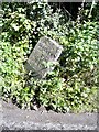
1
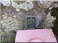
Ordnance Survey Flush Bracket 11822
This can be found on the roadside wall of a building at Trelanvean Farm. The benchmark height is recorded as being 93.411 metres above sea level.
For more detail see : http://www.bench-marks.org.uk/bm22638
Image: © Peter Wood
Taken: 4 May 2017
0.01 miles
2
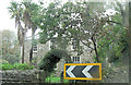
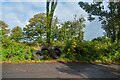
Keep left at Trelanvean Farm
The B3293 continues its gyrations by weaving around this farm near Zoar.
Image: © Stuart Logan
Taken: 11 Oct 2012
0.03 miles
3
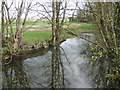
Pond opposite Trelanvean
By a bend in the B3293 Coverack road.
Image: © Jonathan Billinger
Taken: 14 Mar 2007
0.03 miles
4
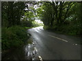
B3293 heading to Zoar
B3293 near Trelanvean heading to Zoar
Image: © Shaun Ferguson
Taken: 24 Aug 2015
0.05 miles
5
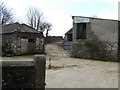
Trelanvean Farm
View from the B3293
Image: © Jonathan Billinger
Taken: 14 Mar 2007
0.05 miles
6
St Keverne : B3293
Along the roadside are some tyres.
Image: © Lewis Clarke
Taken: 1 Oct 2022
0.06 miles
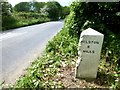
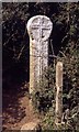
7
Old Milestone by the B3293, east of Trelanvean
Carved stone post by the B3293, in parish of ST KEVERNE (KERRIER District), Trelanvean, East of lay-by, on same side, by the road, on North side of road. Erected by the Local Highways Board in the 19th century.
Inscription reads:-
: St KEVERNE / 2½ / MILES : : HELSTON / 8 / MILES :
Milestone Society National ID: CW_HLSK08.
Image: © Ian Thompson
Taken: 10 Dec 2017
0.12 miles
8
Old Milestone by the B3293, east of Trelanvean
Carved stone post by the B3293, in parish of ST KEVERNE (KERRIER District), Trelanvean, East of lay-by, on same side, by the road, on North side of road. Erected by the Local Highways Board in the 19th century.
Inscription reads:-
: SᵀKEVERNE / 2½ / MILES : : HELSTON / 8 / MILES :
Cornwall & Scilly HER.
HER Number: 178320 https://www.heritagegateway.org.uk/Gateway/Results_Single.aspx?uid=MCO54097&resourceID=1020
Milestone Society National ID: CW_HLSK08.
Image: © Rosy Hanns
Taken: 31 May 2019
0.12 miles
10
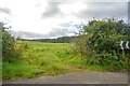
St Keverne : Grassy Field
A field off the B3293.
Image: © Lewis Clarke
Taken: 1 Oct 2022
0.19 miles