IMAGES TAKEN NEAR TO
St. Keverne, HELSTON, TR12 6QQ
Introduction
This page details the photographs taken nearby to TR12 6QQ by members of the Geograph project.
The Geograph project started in 2005 with the aim of publishing, organising and preserving representative images for every square kilometre of Great Britain, Ireland and the Isle of Man.

There are currently over 7.5m images from over14,400 individuals and you can help contribute to the project by visiting https://www.geograph.org.uk
Image Map
Images are licensed for reuse under creativecommons.org/licenses/by-sa/2.0
Notes
- Clicking on the map will re-center to the selected point.
- The higher the marker number, the further away the image location is from the centre of the postcode.
Image Listing (6 Images Found)
Images are licensed for reuse under creativecommons.org/licenses/by-sa/2.0
Image
Details
Distance
1
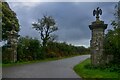
St Keverne : Road
Entrance to Trenoweth Farm.
Image: © Lewis Clarke
Taken: 1 Oct 2022
0.19 miles
2
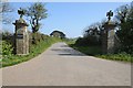
Entrance to Trenoweth Farm
Grand gate piers at the entrance to Trenoweth Farm.
Image: © Philip Halling
Taken: 21 Apr 2019
0.19 miles

4
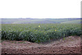
Daffodil field near Trenoweth Farm
The late spring meant that by the time many of the Cornish flowers were ready to harvest, there was already a glut on the market and many were just left to bloom in the fields.
Image: © Trevor Harris
Taken: 13 Apr 2010
0.22 miles
5
Silage bales in a field
Silage bales in a field north of the village of St Keverne.
Image: © Philip Halling
Taken: 21 Apr 2019
0.23 miles
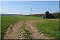
6
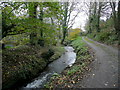
Brook near Trenoweth Mill
Looking east, downstream, as the watercourse heads the final half-mile to the sea at Porthoustock.
Image: © Jonathan Billinger
Taken: 19 Nov 2009
0.25 miles