IMAGES TAKEN NEAR TO
Tregowris, St. Keverne, HELSTON, TR12 6PT
Introduction
This page details the photographs taken nearby to TR12 6PT by members of the Geograph project.
The Geograph project started in 2005 with the aim of publishing, organising and preserving representative images for every square kilometre of Great Britain, Ireland and the Isle of Man.

There are currently over 7.5m images from over14,400 individuals and you can help contribute to the project by visiting https://www.geograph.org.uk
Image Map
Images are licensed for reuse under creativecommons.org/licenses/by-sa/2.0
Notes
- Clicking on the map will re-center to the selected point.
- The higher the marker number, the further away the image location is from the centre of the postcode.
Image Listing (13 Images Found)
Images are licensed for reuse under creativecommons.org/licenses/by-sa/2.0
Image
Details
Distance
1
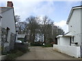
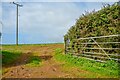
Road to Tregowris
The farm road and footpath leaves the public road at a point between these two cottages.
Image: © Jonathan Billinger
Taken: 14 Mar 2007
0.01 miles
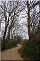
3
St Keverne : Road
A road heading through the countryside.
Image: © Lewis Clarke
Taken: 1 Oct 2022
0.05 miles
4
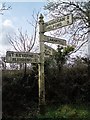
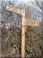
Old Direction Sign - Signpost west of Tregowris, St Keverne Parish
Pyramid spear finial - 4 arms; Cornwall CC iron spear by the UC road, in parish of St Keverne (Kerrier District), West of Tregowris, opposite the North turn of the staggered crossroads.
Surveyed
Milestone Society National ID: CW_SW7722B.
Image: © Milestone Society
Taken: Unknown
0.08 miles
5
St Keverne : Grassy Field
A field seen in the countryside.
Image: © Lewis Clarke
Taken: 1 Oct 2022
0.11 miles
6
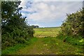
St Keverne : Grassy Field & Gate
A field beyond the gate.
Image: © Lewis Clarke
Taken: 1 Oct 2022
0.17 miles
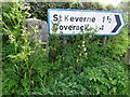
7
Old Direction Sign - Signpost east of Tregowris, St Keverne
No finial - 3 arms; Visick Cone by the UC road, in parish of St Keverne (Kerrier District), East of Tregowris, T-junction, opposite granite guidestone: CW_HLSK10x Image
Cornwall & Scilly HER.
HER Number: MCO55476 https://www.heritagegateway.org.uk/Gateway/Results_Single.aspx?uid=MCO55476&resourceID=1020
Surveyed
Milestone Society National ID: CW_SW7722A
Image: © Milestone Society
Taken: Unknown
0.22 miles
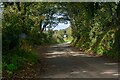
8
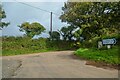
St Keverne : Road
A road at the junction.
Image: © Lewis Clarke
Taken: 1 Oct 2022
0.22 miles
9

Old Guide Stone by the B3293, east of Tregowris
Carved stone by the B3293, in parish of St Keverne (Kerrier District), Tregowris, at junction, next to modern sign, opposite cast iron fingerpost: CW_SW7722A Image
Inscription reads:-
: {<-hand} / Sᵀ. / Llanthony / 1838 / I.B. : : {<-hand} / HELSTON / Sᵀ. / KEVERNE / {hand->} / I.P. :
Carved bench mark on lower right face.
Grade II listed.
List Entry Number: 1328506 https://historicengland.org.uk/listing/the-list/list-entry/1328506
Surveyed
Milestone Society National ID: CW_HLSK10x.
Image: © Rosy Hanns
Taken: 20 Jul 2019
0.23 miles
10
Milestone and modern signpost
Milestone and modern signpost on a road junction near St Keverne.
Image: © Philip Halling
Taken: 22 Apr 2019
0.23 miles