IMAGES TAKEN NEAR TO
St. Keverne, HELSTON, TR12 6PQ
Introduction
This page details the photographs taken nearby to TR12 6PQ by members of the Geograph project.
The Geograph project started in 2005 with the aim of publishing, organising and preserving representative images for every square kilometre of Great Britain, Ireland and the Isle of Man.

There are currently over 7.5m images from over14,400 individuals and you can help contribute to the project by visiting https://www.geograph.org.uk
Image Map
Images are licensed for reuse under creativecommons.org/licenses/by-sa/2.0
Notes
- Clicking on the map will re-center to the selected point.
- The higher the marker number, the further away the image location is from the centre of the postcode.
Image Listing (6 Images Found)
Images are licensed for reuse under creativecommons.org/licenses/by-sa/2.0
Image
Details
Distance
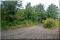
1
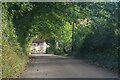
St Keverne : Road
A road heading through the countryside.
Image: © Lewis Clarke
Taken: 1 Oct 2022
0.01 miles
2
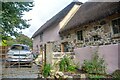
St Keverne : Treleague Barn
A house in the countryside.
Image: © Lewis Clarke
Taken: 1 Oct 2022
0.06 miles
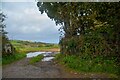
3
A road junction near Treleague Farm
With a sign saying "Beware Slow Tractors".
Image: © David Medcalf
Taken: 9 Sep 2023
0.13 miles
4
St Keverne : Field
A field seen from the road.
Image: © Lewis Clarke
Taken: 1 Oct 2022
0.13 miles
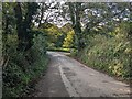
5
St Keverne : Road
Seen at the road junction in the countryside.
Image: © Lewis Clarke
Taken: 1 Oct 2022
0.14 miles
6
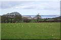
Field with a View
The field is scattered with daffodils, the remnants of previous plantings. The view is out over Falmouth Bay.
Image: © Tony Atkin
Taken: 8 Apr 2010
0.16 miles