IMAGES TAKEN NEAR TO
Garras, HELSTON, TR12 6LH
Introduction
This page details the photographs taken nearby to TR12 6LH by members of the Geograph project.
The Geograph project started in 2005 with the aim of publishing, organising and preserving representative images for every square kilometre of Great Britain, Ireland and the Isle of Man.

There are currently over 7.5m images from over14,400 individuals and you can help contribute to the project by visiting https://www.geograph.org.uk
Image Map
Images are licensed for reuse under creativecommons.org/licenses/by-sa/2.0
Notes
- Clicking on the map will re-center to the selected point.
- The higher the marker number, the further away the image location is from the centre of the postcode.
Image Listing (3 Images Found)
Images are licensed for reuse under creativecommons.org/licenses/by-sa/2.0
Image
Details
Distance
1
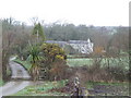
Trevassack
The house is set amongst woods and rough pasture in a fold of land in the centre of the Lizard peninsula. The palm-like plant is a Cordyline australis, also known as Torbay Palm.
Image: © Jonathan Billinger
Taken: 14 Mar 2007
0.02 miles
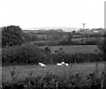
3
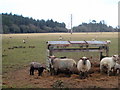
Sheep pasture near Trevassack
In the background is the edge of Dobnas Plantation.
Image: © Rod Allday
Taken: 11 Mar 2010
0.20 miles