IMAGES TAKEN NEAR TO
St. Martins Green, HELSTON, TR12 6BW
Introduction
This page details the photographs taken nearby to St. Martins Green, TR12 6BW by members of the Geograph project.
The Geograph project started in 2005 with the aim of publishing, organising and preserving representative images for every square kilometre of Great Britain, Ireland and the Isle of Man.

There are currently over 7.5m images from over14,400 individuals and you can help contribute to the project by visiting https://www.geograph.org.uk
Image Map
Images are licensed for reuse under creativecommons.org/licenses/by-sa/2.0
Notes
- Clicking on the map will re-center to the selected point.
- The higher the marker number, the further away the image location is from the centre of the postcode.
Image Listing (5 Images Found)
Images are licensed for reuse under creativecommons.org/licenses/by-sa/2.0
Image
Details
Distance
1
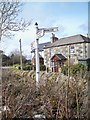
Old Direction Sign - Signpost by St Martin, St Martin in Meneage parish
Pyramid spear finial - 3 arms; Cornwall CC iron spear by the UC road, in parish of St Martin in Meneage (Kerrier District), centre of St Martin, behind stone wall.
Cornwall & Scilly HER.
HER Number: MCO55498 https://www.heritagegateway.org.uk/Gateway/Results_Single.aspx?uid=MCO55498&resourceID=1020
Surveyed
Milestone Society National ID: CW_SW7323
Image: © Milestone Society
Taken: Unknown
0.03 miles
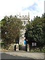
3

St Martin's churchyard
The threatening sky didn't come to anything!
Image: © Jonathan Billinger
Taken: 14 Mar 2007
0.21 miles
5
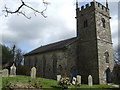
Parish church of St Martin-in-Meneage
Image: © Jonathan Billinger
Taken: 14 Mar 2007
0.24 miles