IMAGES TAKEN NEAR TO
St. Clement, TRURO, TR1 1TF
Introduction
This page details the photographs taken nearby to TR1 1TF by members of the Geograph project.
The Geograph project started in 2005 with the aim of publishing, organising and preserving representative images for every square kilometre of Great Britain, Ireland and the Isle of Man.

There are currently over 7.5m images from over14,400 individuals and you can help contribute to the project by visiting https://www.geograph.org.uk
Image Map
Images are licensed for reuse under creativecommons.org/licenses/by-sa/2.0
Notes
- Clicking on the map will re-center to the selected point.
- The higher the marker number, the further away the image location is from the centre of the postcode.
Image Listing (21 Images Found)
Images are licensed for reuse under creativecommons.org/licenses/by-sa/2.0
Image
Details
Distance
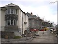
4
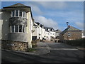
Belvedere, Truro
An award-winning development by local firm, Rosemullion Homes. Tony Atkin's picture (http://www.geograph.org.uk/photo/99779) shows these houses under construction.
Image: © Rod Allday
Taken: 4 Apr 2009
0.12 miles
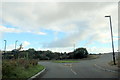
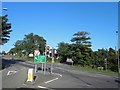
6
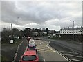
Junction on Tregolls Road
This is the main road into Truro from the east. It's all downhill from here to the city centre.
Image: © Tony Atkin
Taken: 2 Jan 2006
0.16 miles
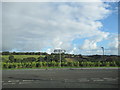
7
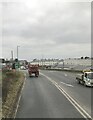
New Housing Development
On the outskirts of Truro.
Image: © Tony Atkin
Taken: 2 Jan 2006
0.16 miles
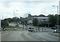
8
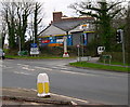
A39 junction with A390 Tregolls Road traffic lights, Truro
Image: © Steve Fareham
Taken: 20 Aug 2013
0.18 miles