
IMAGES TAKEN NEAR TO
The Hayes, Bodmin Road, TRURO, TR1 1FY
Introduction
This page details the photographs taken nearby to The Hayes, Bodmin Road, TR1 1FY by members of the Geograph project.
The Geograph project started in 2005 with the aim of publishing, organising and preserving representative images for every square kilometre of Great Britain, Ireland and the Isle of Man.

There are currently over 7.5m images from over14,400 individuals and you can help contribute to the project by visiting https://www.geograph.org.uk
Image Map
Images are licensed for reuse under creativecommons.org/licenses/by-sa/2.0
Notes
- Clicking on the map will re-center to the selected point.
- The higher the marker number, the further away the image location is from the centre of the postcode.
Image Listing (14 Images Found)
Images are licensed for reuse under creativecommons.org/licenses/by-sa/2.0
Image
Details
Distance
1
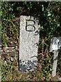
Old Boundary Stone north of Trenerry Toll House, Truro
Carved boundary stone in Bodmin Road, just North of Trenerry Toll House. West side of road, against stone wall, south of 'Give Way' sign.
Inscription reads:-
B
Grade II listed.
List Entry Number: 1201438 https://historicengland.org.uk/listing/the-list/list-entry/1201438
Milestone Society National ID: CW_XTRU
Image: © Rosy Hanns
Taken: 5 May 2019
0.07 miles
2
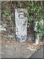
Old Guide Stone by old Bodmin Road, junction with Moresk Road, opposite Trenerry Tollhouse
The Guide Stone is located in stone faced bank on the West of the road. Parish of Truro (Carrick District). Carved stone post, Bodmin post design, erected by the Truro turnpike trust in the 18th Century.
Inscription reads:-
B
Grade II listed. List Entry Number: 1201438 https://historicengland.org.uk/listing/the-list/list-entry/1201438
Milestone Society National ID: CW_XTRU
Image: © Paul Barnett
Taken: 18 Jul 2023
0.07 miles
3
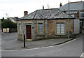
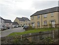
Trenerry Tollhouse by Bodmin Road, Truro
Tollhouse by the unclassified road (was A3076), in the parish of Truro (Carrick District); Trenerry Toll House, Bodmin Road, Truro.
Grade II listed.
List Entry Number: 1280841 https://historicengland.org.uk/listing/the-list/list-entry/1280841
Surveyed
Milestone Society National ID: CW.STC02
Image: © Alan Rosevear
Taken: 26 Feb 2009
0.09 miles


9
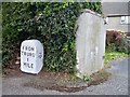
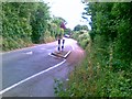
Old Milestone by Old Bodmin Road into Truro
Carved stone post by the UC road, in parish of TRURO (CARRICK District), Old Bodmin road into Truro, in garden hedge, amongst suburban houses, on West side of road. Truro stone, erected by the Truro turnpike trust in the 18th century.
Inscription reads:-
FROM
TRURO
1
MILE
Carved benchmark on right side.
Grade II Listed. List Entry Number:1396422
https://historicengland.org.uk/listing/the-list/list-entry/1396422
Milestone Society National ID: CW_TOMI01o.
Image: © Ian Thompson
Taken: 1 Apr 1996
0.24 miles
10
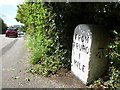
Old Milestone by Old Bodmin Road into Truro
Carved stone post by the UC road, in parish of TRURO (CARRICK District), Old Bodmin Road into Truro, in garden hedge, amongst suburban houses, on West side of road. Truro stone, erected by the Truro turnpike trust in the 18th century.
Inscription reads:-
FROM
TRURO
1
MILE
Carved benchmark on right side.
Grade II listed.
List Entry Number: 1396422 https://historicengland.org.uk/listing/the-list/list-entry/1396422
Milestone Society National ID: CW_TOMI01o.
Image: © Rosy Hanns
Taken: 5 May 2019
0.24 miles