IMAGES TAKEN NEAR TO
Gwel Nans Tregeworra, TRURO, TR1 1AE
Introduction
This page details the photographs taken nearby to Gwel Nans Tregeworra, TR1 1AE by members of the Geograph project.
The Geograph project started in 2005 with the aim of publishing, organising and preserving representative images for every square kilometre of Great Britain, Ireland and the Isle of Man.

There are currently over 7.5m images from over14,400 individuals and you can help contribute to the project by visiting https://www.geograph.org.uk
Image Map
Images are licensed for reuse under creativecommons.org/licenses/by-sa/2.0
Notes
- Clicking on the map will re-center to the selected point.
- The higher the marker number, the further away the image location is from the centre of the postcode.
Image Listing (32 Images Found)
Images are licensed for reuse under creativecommons.org/licenses/by-sa/2.0
Image
Details
Distance
1
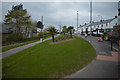
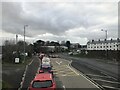
Truro : Newquay Road
Looking along Newquay Road and the pavement alongside it.
Image: © Lewis Clarke
Taken: 19 Apr 2017
0.03 miles
2
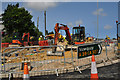
Truro : A39 Roadworks
Roadworks alongside the A39 in Truro.
Image: © Lewis Clarke
Taken: 17 Jul 2015
0.03 miles
3
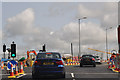
Truro : The A39
The A39 heads through some roadworks on the city outskirts.
Image: © Lewis Clarke
Taken: 17 Jul 2015
0.04 miles
6
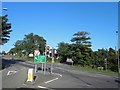
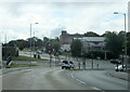
A39 junction with A390 Tregolls Road traffic lights, Truro
Image: © Steve Fareham
Taken: 20 Aug 2013
0.05 miles
7
Junction on Tregolls Road
This is the main road into Truro from the east. It's all downhill from here to the city centre.
Image: © Tony Atkin
Taken: 2 Jan 2006
0.05 miles
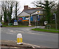
8
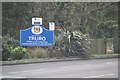
Truro : City Sign on Tregolls Road
Looking towards the sign welcoming visitors into the city of Truro.
Image: © Lewis Clarke
Taken: 23 Feb 2012
0.07 miles
9
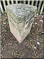
Old Milestone by A39, Tregols Road, by old workhouse
The Milestone is located on the verge, on the East of the road. Parish of Truro (Carrick District). Metal plate attached to stone post, Truro iron plate design, erected by the Truro turnpike trust in the 19th Century, large chip centre top. An earlier photograph can be found here: https://www.geograph.org.uk/photo/5623217
Inscription reads:-
TRURO / 1 / FALMOUTH / 11½ : : BODMIN / 23¼ / LONDON / 249
Grade II listed. List Entry Number: 1396601 https://historicengland.org.uk/listing/the-list/list-entry/1396601
Milestone Society National ID: CW_BMTO23
Image: © Paul Barnett
Taken: 18 Jul 2023
0.07 miles
10
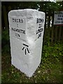
Old Milestone by the A39, north east Truro
Metal plates attached to stone post by the A39, in parish of TRURO (CARRICK District), Tregols Road, by old workhouse, on the verge, on South side of road. Truro iron plate, Erected by the Truro turnpike trust in the 19th century.
Inscription reads:-
: TRURO / 1 / FALMOUTH / 11½ : : BODMIN / 23¼ / LONDON / 249 :
Carved benchmark on front face.
Grade II Listed. List Entry Number: 1396601
https://historicengland.org.uk/listing/the-list/list-entry/1396601
Milestone Society National ID: CW_BMTO23.
Image: © Ian Thompson
Taken: 1 Apr 1996
0.08 miles