
IMAGES TAKEN NEAR TO
Tregew Road, FALMOUTH, TR11 5TF
Introduction
This page details the photographs taken nearby to Tregew Road, TR11 5TF by members of the Geograph project.
The Geograph project started in 2005 with the aim of publishing, organising and preserving representative images for every square kilometre of Great Britain, Ireland and the Isle of Man.

There are currently over 7.5m images from over14,400 individuals and you can help contribute to the project by visiting https://www.geograph.org.uk
Image Map
Images are licensed for reuse under creativecommons.org/licenses/by-sa/2.0
Notes
- Clicking on the map will re-center to the selected point.
- The higher the marker number, the further away the image location is from the centre of the postcode.
Image Listing (8 Images Found)
Images are licensed for reuse under creativecommons.org/licenses/by-sa/2.0
Image
Details
Distance

2

Minor Road Junction
The hedgerows here are nearly all grown out into lines of trees and bushes making the narrow roads shaded and hiding the fields from view.
Image: © Tony Atkin
Taken: 5 Jul 2006
0.08 miles
3

Tregew
Looking down the hill towards Little Falmouth.
Image: © David Dixon
Taken: 1 Aug 2010
0.11 miles
4

Stile on the Footpath
This type of stile is not unusual for this part of the country, being a gap in the field wall with granite stepping blocks inserted across the gap. What is unusual is that three of the blocks are round and smooth tapered cylinders with a square end. The two blocks on the far side of the stile are the more normal rough cut square shape. It seems likely that the three round blocks were originally cut for another purpose, but I don't know what that purpose might be.
Image: © Tony Atkin
Taken: 5 Jul 2006
0.13 miles
5
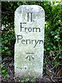
Old Milestone north of Flushing
Carved stone post by the UC road, in parish of MYLOR (CARRICK District), Tregew, Northern outskirts of Flushing, on the verge beside footpath, on West side of road. Gravestone, erected by the parish in the 19th century.
Inscription reads:-
II
From
Penryn
Carved benchmark on lower face.
Grade II listed.
List Entry Number: 1328622 https://historicengland.org.uk/listing/the-list/list-entry/1328622
Milestone Society National ID: CW_PR02.
Image: © Rosy Hanns
Taken: 27 Jun 2019
0.16 miles
6
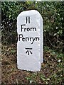
Old Milestone north of Flushing
Carved stone post by the UC road, in parish of MYLOR (CARRICK District), Tregew, Northern outskirts of Flushing, on the verge beside footpath, on West side of road. Gravestone, erected by the parish in the 19th century.
Inscription reads:-
II
From
Penryn
Carved benchmark on lower face.
Grade II Listed. List Entry Number: 1328622
https://historicengland.org.uk/listing/the-list/list-entry/1328622
Milestone Society National ID: CW_PR02.
Image: © Ian Thompson
Taken: 1 Oct 1999
0.16 miles
7
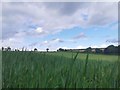
Trefusis Barton
View from the public footpath, walking from Flushing village, over the hills towards Mylor Boatyard. A grain field on a sunny day during lock down.
Image: © Oona Wiggan
Taken: 1 Jun 2020
0.20 miles
8
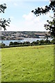
Pasture above Little Falmouth
Falmouth Yacht Marina on the other side of the Penryn River.
Image: © Rod Allday
Taken: 14 Aug 2008
0.20 miles