IMAGES TAKEN NEAR TO
Willow Close, FALMOUTH, TR11 5SG
Introduction
This page details the photographs taken nearby to Willow Close, TR11 5SG by members of the Geograph project.
The Geograph project started in 2005 with the aim of publishing, organising and preserving representative images for every square kilometre of Great Britain, Ireland and the Isle of Man.

There are currently over 7.5m images from over14,400 individuals and you can help contribute to the project by visiting https://www.geograph.org.uk
Image Map
Images are licensed for reuse under creativecommons.org/licenses/by-sa/2.0
Notes
- Clicking on the map will re-center to the selected point.
- The higher the marker number, the further away the image location is from the centre of the postcode.
Image Listing (9 Images Found)
Images are licensed for reuse under creativecommons.org/licenses/by-sa/2.0
Image
Details
Distance
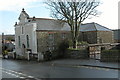
1
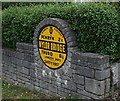
AA Village Sign
This old Automobile Association supplied village sign is built into a garden wall.
Image: © Tony Atkin
Taken: 5 Jul 2006
0.13 miles
3
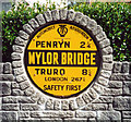
Old AA Sign on Comfort Road, Mylor Bridge
Old AA Sign set in the front garden wall of No 36 on the north side of Comfort Road, Mylor Bridge, 2 miles northeast of Falmouth. Mylor parish.
This is the Circular, village name on black band, no Motor Union symbol or name type, dating from 1923, showing distances Penryn 2¼ Truro 8½ London 267¾.
There were five series of AA signs, mostly dating from 1923 and made by Francis & Co / Franco in Deptford, London. The village name and distance to London were displayed.
See also https://www.flickr.com/photos/boffinpc/51319647860 and http://www.geograph.org.uk/photo/199073.
Milestone Society National ID: CW-MYLBR
Image: © Milestone Society
Taken: Unknown
0.15 miles
4
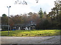
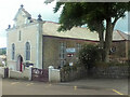
Mylor Bridge
The village of Mylor Bridge probably grew up around the bridge which is at the head of Mylor Creek and the lowest crossing point. This photograph looks from the south, over the bridge to the heart of the village.
Image: © Tony Atkin
Taken: 5 Jul 2006
0.21 miles
7
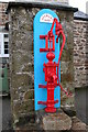
Old water pump in Mylor Bridge
The pump has a plaque with the words 'Gilbert 1852'
Image: © Philip Halling
Taken: 17 Feb 2006
0.24 miles
8
Direction Sign ? Signpost on Waterings Road, Mylor Bridge
Located on the south side of the Y-junction of Rosehill and Waterings Road in Mylor Bridge in Mylor parish. 3 arms, 1 missing, and onion finial.
Grade II listed. List Entry Number: 1391789
https://historicengland.org.uk/listing/the-list/list-entry/1391789.
Milestone Society National ID: CW_SW8036A
Image: © I Thompson
Taken: Unknown
0.24 miles
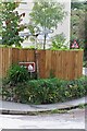
9
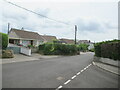
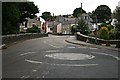
Springfield Park, Bell's Hill junction, Mylor Bridge
Image: © Roy Hughes
Taken: 26 Jun 2023
0.24 miles