IMAGES TAKEN NEAR TO
Greenfields Close, FALMOUTH, TR11 5EX
Introduction
This page details the photographs taken nearby to Greenfields Close, TR11 5EX by members of the Geograph project.
The Geograph project started in 2005 with the aim of publishing, organising and preserving representative images for every square kilometre of Great Britain, Ireland and the Isle of Man.

There are currently over 7.5m images from over14,400 individuals and you can help contribute to the project by visiting https://www.geograph.org.uk
Image Map
Images are licensed for reuse under creativecommons.org/licenses/by-sa/2.0
Notes
- Clicking on the map will re-center to the selected point.
- The higher the marker number, the further away the image location is from the centre of the postcode.
Image Listing (57 Images Found)
Images are licensed for reuse under creativecommons.org/licenses/by-sa/2.0
Image
Details
Distance
1
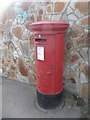
Mawnan Smith: postbox № TR11 61
A fat George VI-reign postbox stands outside Image
Image: © Chris Downer
Taken: 15 Oct 2013
0.05 miles
2
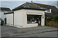
MS Electrical
MS for Mawnan Smith of course. It is good to see small business thriving in rural areas. At least, this one gave the impression of thriving although I was not able to avail myself of anything. I was about to lead a walk.
Image: © Graham Horn
Taken: 20 Oct 2011
0.06 miles
3
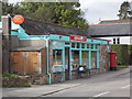
Mawnan Smith: the post office
The Spar branded village store incorporates the village post office and is pictured a few minutes before it reopens after lunch at 2 o'clock.
The village has had a post office since 12 March 1848.
Image: © Chris Downer
Taken: 15 Oct 2013
0.06 miles
4
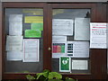
The Parish Council noticeboard in Mawnan Smith
Full of notices and announcements relating to the Covid-19 pandemic.
Image: © Rod Allday
Taken: 30 Mar 2020
0.06 miles
5
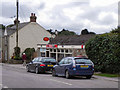
Mawnan Smith Post Office and Spar Shop
On Sampys Hill, near the centre of the village.
Update April 2021:
I have been informed by the current owners that “this business is no longer a Spar or a post office. It is now called The Village Shop Mawnan Smith”.
Image: © David Dixon
Taken: 30 Jul 2010
0.06 miles
6
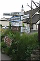
Old Direction Sign - Signpost in Mawnan Smith
Cone finial - Legacy Listed 66218; by the UC road, in parish of Mawnan (Kerrier District), Mawnan Smith village centre, on hedge in village centre.
Grade II Listed. List Entry Number: 1142043
https://historicengland.org.uk/listing/the-list/list-entry/1142043
Surveyed
Milestone Society National ID: CW_SW7728B
Image: © Milestone Society
Taken: Unknown
0.06 miles
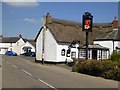
7
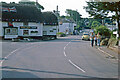
Mawnan Smith
The centre of this Cornish village is dominated by its thatched pub, the Red Lion. Here in the summer of 1977 it was decorated with a union flag and bunting to celebrate the silver jubilee of Queen Elizabeth II. Devenish owned a large estate of west Cornwall pubs in the 1970s - the beers were brewed at Redruth - but the company no longer exists. The road ahead through the village leads to Helford Passage. Note the Barclays Bank sign on the right of the picture; it seems hard to believe now, in an age when banks are closing branches in quite large towns, that they once had a presence in such rural places.
Image: © Stephen McKay
Taken: Unknown
0.07 miles
8
The Village of Mawnan Smith
The parish is called Mawnan. It is assumed the word 'Smith' added to the name of this village was something to do with Blacksmiths.
Image: © Tony Atkin
Taken: 1 May 2006
0.07 miles
10
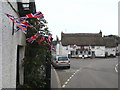
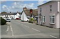
Bunting decorating cottages in the centre of Mawnan Smith village
The village is decorated to celebrate the wedding of Prince William and Catherine Middleton on 29 April 2011. In the background is the Red Lion public house Image
Image: © Rod Allday
Taken: 29 Apr 2011
0.07 miles