IMAGES TAKEN NEAR TO
Boslowick Road, FALMOUTH, TR11 4QD
Introduction
This page details the photographs taken nearby to Boslowick Road, TR11 4QD by members of the Geograph project.
The Geograph project started in 2005 with the aim of publishing, organising and preserving representative images for every square kilometre of Great Britain, Ireland and the Isle of Man.

There are currently over 7.5m images from over14,400 individuals and you can help contribute to the project by visiting https://www.geograph.org.uk
Image Map
Images are licensed for reuse under creativecommons.org/licenses/by-sa/2.0
Notes
- Clicking on the map will re-center to the selected point.
- The higher the marker number, the further away the image location is from the centre of the postcode.
Image Listing (3 Images Found)
Images are licensed for reuse under creativecommons.org/licenses/by-sa/2.0
Image
Details
Distance
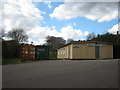
2
Swanvale oil depot
The grass covered mounds are underground oil tanks. There is a pipeline from this former MOD depot to St Mawgan air base on the north coast near Newquay.
Image: © Rod Allday
Taken: 9 Apr 2008
0.20 miles
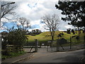
3

Early morning sun on the boardwalk through Prislow Woods
Image: © Rod Allday
Taken: 12 Jan 2022
0.24 miles