IMAGES TAKEN NEAR TO
Bar Road, FALMOUTH, TR11 4NN
Introduction
This page details the photographs taken nearby to Bar Road, TR11 4NN by members of the Geograph project.
The Geograph project started in 2005 with the aim of publishing, organising and preserving representative images for every square kilometre of Great Britain, Ireland and the Isle of Man.

There are currently over 7.5m images from over14,400 individuals and you can help contribute to the project by visiting https://www.geograph.org.uk
Image Map
Images are licensed for reuse under creativecommons.org/licenses/by-sa/2.0
Notes
- Clicking on the map will re-center to the selected point.
- The higher the marker number, the further away the image location is from the centre of the postcode.
Image Listing (269 Images Found)
Images are licensed for reuse under creativecommons.org/licenses/by-sa/2.0
Image
Details
Distance
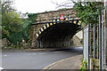
3
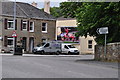
Falmouth : Bar Road
Looking along Bar Road in Falmouth.
Image: © Lewis Clarke
Taken: 13 Jul 2015
0.04 miles
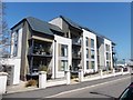
4
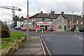
Spar shop in Bar Road, Falmouth
To the right runs a terrace of ex-railway cottages. No mistaking where the harbour is!
Image: © John Lucas
Taken: 9 Feb 2023
0.05 miles
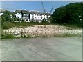
7
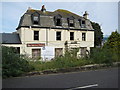
The Admiral Nelson
The burned out remains of The Admiral Nelson in Falmouth.
Image: © Philip Halling
Taken: 29 Sep 2010
0.07 miles
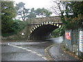
8
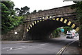
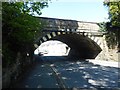
Falmouth : Bar Road
Bar Road heading underneath the railway bridge.
Image: © Lewis Clarke
Taken: 13 Jul 2015
0.07 miles