IMAGES TAKEN NEAR TO
Rame Croft, PENRYN, TR10 9NB
Introduction
This page details the photographs taken nearby to Rame Croft, TR10 9NB by members of the Geograph project.
The Geograph project started in 2005 with the aim of publishing, organising and preserving representative images for every square kilometre of Great Britain, Ireland and the Isle of Man.

There are currently over 7.5m images from over14,400 individuals and you can help contribute to the project by visiting https://www.geograph.org.uk
Image Map
Images are licensed for reuse under creativecommons.org/licenses/by-sa/2.0
Notes
- Clicking on the map will re-center to the selected point.
- The higher the marker number, the further away the image location is from the centre of the postcode.
Image Listing (18 Images Found)
Images are licensed for reuse under creativecommons.org/licenses/by-sa/2.0
Image
Details
Distance
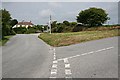
1
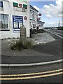
Old Guide Stone by A394, Rame Cross
The Guide Stone is located in pavement on the North of the road. Parish of Wendron (Kerrier District). Carved stone post, Helston facets design, erected by the Helston turnpike trust in the 19th Century, edge chips. An earlier photograph can be found here: https://www.geograph.org.uk/photo/6061353
Inscription reads:-
TO / S / STITHIAN / GWENNAP / REDRUTH : : TO / PENRYN / TH / FALMOU / TRURO
Grade II listed. List Entry Number: 1141997 https://historicengland.org.uk/listing/the-list/list-entry/1141997
Milestone Society National ID: CW_XWEND
Image: © Paul Barnett
Taken: 21 Jun 2023
0.05 miles
2
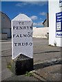
Old Guide Stone by the A394, Rame Cross, Wendron parish
Carved guide stone by the A394, in parish of Wendron (Kerrier District), Rame Cross, in pavement.
Inscription reads:-
: TO / STITHIAN / GWENNAP / REDRUTH : : TO / PENRYN / TH / FALMOU / TRURO :
Grade II listed.
List Entry Number: 1141997 https://historicengland.org.uk/listing/the-list/list-entry/1141997
Surveyed
Milestone Society National ID: CW_XWEND
Image: © Milestone Society
Taken: Unknown
0.06 miles
3
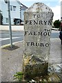
Old Guide Stone by the A394 at Rame Cross, Wendron parish
Carved guide stone by the A394, in parish of Wendron (Kerrier District), Rame Cross, in pavement.
Inscription reads:-
: TO / STITHIAN / GWENNAP / REDRUTH : : TO / PENRYN / TH / FALMOU / TRURO :
Grade II listed.
List Entry Number: 1141997 https://historicengland.org.uk/listing/the-list/list-entry/1141997
Surveyed
Milestone Society National ID: CW_XWEND
Image: © Rosy Hanns
Taken: 20 Jul 2019
0.06 miles
4
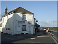
Rame Post Office and general store
A wedge-shaped building by the A394 Penryn to Helston road.
Image: © Jonathan Billinger
Taken: 13 Mar 2007
0.06 miles

6

Rame Common
TUMP in silage field with access via gate near replica cross.
Name: Rame Common
Hill number: 17606
Height: 206m / 676ft
Parent (Ma/M): 2886 Carnmenellis
Section: 40: Cornwall & Devon
County/UA: Cornwall (CoU)
Class: Tump (200-299m)
Grid ref: SW727338 (est)
Drop: 35m
Col: 171m SW714345
Image: © Rude Health
Taken: 9 May 2015
0.11 miles
8
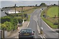
Rame : The A394
Looking along the A394 as it heads near to Rame.
Image: © Lewis Clarke
Taken: 17 Jul 2015
0.13 miles
9
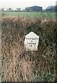
Old Milestone by the A394 in Rame
Carved stone post by the A394, in parish of WENDRON (KERRIER District), Rame, opposite Halfway House Inn, high on bank (Level with old road?), on South side of road. Helston facets, erected by the Helston turnpike trust in the 19th century.
Inscription reads:-
: HELSTON / 6 / PENZANCE / 19 : : FALMOUTH / 6 / TRURO / 10 :
Grade II Listed. List Entry Number: 1309550
https://historicengland.org.uk/listing/the-list/list-entry/1309550
Milestone Society National ID: CW_PZTO19.
Image: © Ian Thompson
Taken: 10 Dec 2017
0.13 miles
10
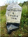
Old Milestone by the A394 in Rame
Carved stone post by the A394, in parish of WENDRON (KERRIER District), Rame, opposite Halfway House Inn, high on bank (Level with old road?), on East side of road. Helston facets, erected by the Helston turnpike trust in the 19th century.
Inscription reads:-
: HELSTON / 6 / PENZANCE / 19 : : FALMOUTH / 6 / TRURO / 10¾ :
Grade II listed.
List Entry Number: 1309550 https://historicengland.org.uk/listing/the-list/list-entry/1309550
Milestone Society National ID: CW_PZTO19.
Image: © Rosy Hanns
Taken: 20 Jul 2019
0.13 miles