IMAGES TAKEN NEAR TO
Kernick Industrial Estate, PENRYN, TR10 9LU
Introduction
This page details the photographs taken nearby to Kernick Industrial Estate, TR10 9LU by members of the Geograph project.
The Geograph project started in 2005 with the aim of publishing, organising and preserving representative images for every square kilometre of Great Britain, Ireland and the Isle of Man.

There are currently over 7.5m images from over14,400 individuals and you can help contribute to the project by visiting https://www.geograph.org.uk
Image Map
Images are licensed for reuse under creativecommons.org/licenses/by-sa/2.0
Notes
- Clicking on the map will re-center to the selected point.
- The higher the marker number, the further away the image location is from the centre of the postcode.
Image Listing (5 Images Found)
Images are licensed for reuse under creativecommons.org/licenses/by-sa/2.0
Image
Details
Distance
1

Spring is on the way!
Spring bedding plants on sale in B & Q at Penryn.
Image: © Rod Allday
Taken: 23 Feb 2017
0.15 miles
2

B & Q
56 Kernick Road, Penryn (close to Mabe Burnthouse).
Image: © David Dixon
Taken: 1 Aug 2010
0.17 miles

4
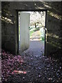
The entrance to the old kitchen garden at Tremough House
Now part of the Penryn Campus of Exeter and Falmouth Universities.
Image: © Rod Allday
Taken: 9 Apr 2022
0.20 miles
5
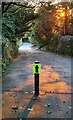
Early morning on a lane at Penryn Campus
This lane is now part of the campus at the combined universities of Exeter and Falmouth, centred around Tremough House, and this lane is part of the original estate grounds. The direction arrow is guiding participants to the recently established Penryn Campus parkrun.
Image: © Rod Allday
Taken: 30 Oct 2021
0.24 miles