IMAGES TAKEN NEAR TO
Rame Common Cross, PENRYN, TR10 9LP
Introduction
This page details the photographs taken nearby to TR10 9LP by members of the Geograph project.
The Geograph project started in 2005 with the aim of publishing, organising and preserving representative images for every square kilometre of Great Britain, Ireland and the Isle of Man.

There are currently over 7.5m images from over14,400 individuals and you can help contribute to the project by visiting https://www.geograph.org.uk
Image Map
Images are licensed for reuse under creativecommons.org/licenses/by-sa/2.0
Notes
- Clicking on the map will re-center to the selected point.
- The higher the marker number, the further away the image location is from the centre of the postcode.
Image Listing (8 Images Found)
Images are licensed for reuse under creativecommons.org/licenses/by-sa/2.0
Image
Details
Distance
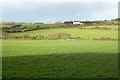
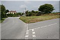
3
Heathland, Wendron
Rame Common gives way to farmland, currently fields of stubble, below Little Rame Farm.
Image: © Andrew Smith
Taken: 7 Jan 2023
0.16 miles
7
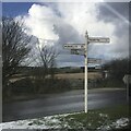
Fingerpost
Milestone Society National ID: CW_SW7234
Image: © Paul Barnett
Taken: 18 Jan 2023
0.23 miles
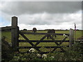
8
Old Direction Sign - Signpost south of Little Rame Farm, Wendron Parish
Cone finial - Arm 3 has rivetted repair; by the UC road, in parish of Wendron (Kerrier District), near Little Rame Farm, on island on crossroads.
Grade II listed. List Entry Number: 1142041
https://historicengland.org.uk/listing/the-list/list-entry/1142041
Surveyed
Milestone Society National ID: CW_SW7234
Image: © Milestone Society
Taken: Unknown
0.23 miles