1
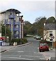
Dappled Shade
The trees are beginning to come into leaf, giving some shade to this country lane where a large house is separated from the road by an equally imposing wall.
Image: © Tony Atkin
Taken: 29 Apr 2006
0.03 miles
2
Old Milestone by Old Falmouth Road, north of Penryn
Carved stone post by the UC road, in parish of PENRYN (CARRICK District), Bella Vista, Old Falmouth Road, built into stone wall on edge of road, on East side of road. Truro stone, erected by the Truro turnpike trust in the 19th century.
Inscription reads:-
FROM
TRURO
8
MILES
Grade II listed.
List Entry Number: 1187603 https://historicengland.org.uk/listing/the-list/list-entry/1187603
Milestone Society National ID: CW_TOOF08.
Image: © Rosy Hanns
Taken: 26 Jun 2019
0.07 miles
3
Old Milestone by Old Falmouth Road, north of Penryn
Carved stone post by the UC road, in parish of PENRYN (CARRICK District), Bella Vista, Old Falmouth Road, built into stone wall on edge of road, on East side of road. Truro stone, erected by the Truro turnpike trust in the 19th century.
Inscription reads:-
FROM
TRURO
8
MILES
Grade II Listed. List Entry Number:1187603
https://historicengland.org.uk/listing/the-list/list-entry/1187603
Milestone Society National ID: CW_TOOF08.
Image: © Ian Thompson
Taken: 1 Sep 2005
0.07 miles
4
Penryn : Brown's Hill
Looking towards Brown's Hill from The Praze.
Image: © Lewis Clarke
Taken: 13 Jul 2015
0.12 miles
5
Penryn : Brown's Hill
Brown's Hill and Millennium Apartments in the background.
Image: © Lewis Clarke
Taken: 13 Jul 2015
0.14 miles
6
Cornwall : The B3292
The B3292 heading out from Penryn.
Image: © Lewis Clarke
Taken: 13 Jul 2015
0.16 miles
7
B3292 north-west of Penryn
Before the town was by-passed, this road took much of the traffic for Falmouth
Image: © David Smith
Taken: 22 Mar 2013
0.16 miles
8
View from The Maritime Line
Image: © N Chadwick
Taken: 28 Apr 2018
0.18 miles
9
21st Century Apartment and 19th Century House
A juxtaposition of styles and ages on this road on the northern edge of Penryn.
Image: © Tony Atkin
Taken: 29 Apr 2006
0.20 miles
10
Three-cornered Leek - Allium triquetrum
Looking something like large snowdrops, these plants are extremely common on the road verges in this part of Cornwall.
Image: © Tony Atkin
Taken: 29 Apr 2006
0.20 miles


