IMAGES TAKEN NEAR TO
Edgcumbe, PENRYN, TR10 9EG
Introduction
This page details the photographs taken nearby to TR10 9EG by members of the Geograph project.
The Geograph project started in 2005 with the aim of publishing, organising and preserving representative images for every square kilometre of Great Britain, Ireland and the Isle of Man.

There are currently over 7.5m images from over14,400 individuals and you can help contribute to the project by visiting https://www.geograph.org.uk
Image Map
Images are licensed for reuse under creativecommons.org/licenses/by-sa/2.0
Notes
- Clicking on the map will re-center to the selected point.
- The higher the marker number, the further away the image location is from the centre of the postcode.
Image Listing (9 Images Found)
Images are licensed for reuse under creativecommons.org/licenses/by-sa/2.0
Image
Details
Distance
2
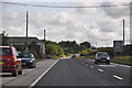
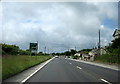
Cornwall : The A394
The A394 heading through the county of Cornwall.
Image: © Lewis Clarke
Taken: 17 Jul 2015
0.11 miles
6
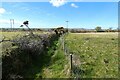
Pasture, Wendron
A footpath passes between small fields having left the A394 at Butteriss Farm.
Image: © Andrew Smith
Taken: 9 Apr 2022
0.13 miles

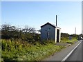
8
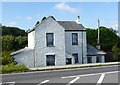
Tollhouse, Butteriss Gate
Tollhouse by the A394, in the parish of Wendron (Kerrier District), Penrose, Main Road, Butteriss Gate.
Cornwall & Scilly HER.
HER Number: 18424 https://www.heritagegateway.org.uk/Gateway/Results_Single.aspx?uid=MCO24983&resourceID=1020
Surveyed
Milestone Society National ID: CW.WEN
Image: © Alan Rosevear
Taken: 10 Sep 2014
0.23 miles
9
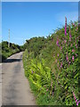
Minor road between Retanna and Rame Common
Image: © Rod Allday
Taken: 10 Jun 2008
0.24 miles