IMAGES TAKEN NEAR TO
Treverva, PENRYN, TR10 9BW
Introduction
This page details the photographs taken nearby to TR10 9BW by members of the Geograph project.
The Geograph project started in 2005 with the aim of publishing, organising and preserving representative images for every square kilometre of Great Britain, Ireland and the Isle of Man.

There are currently over 7.5m images from over14,400 individuals and you can help contribute to the project by visiting https://www.geograph.org.uk
Image Map
Images are licensed for reuse under creativecommons.org/licenses/by-sa/2.0
Notes
- Clicking on the map will re-center to the selected point.
- The higher the marker number, the further away the image location is from the centre of the postcode.
Image Listing (22 Images Found)
Images are licensed for reuse under creativecommons.org/licenses/by-sa/2.0
Image
Details
Distance
1
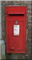
Elizabeth II postbox, Treverva
Postbox No. TR10 59.
See Image] for context.
Image: © JThomas
Taken: 12 Jul 2017
0.06 miles
2
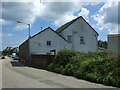
Cottages, Treverva
Showing position of Postbox No. TR10 59.
See Image] for postbox.
Image: © JThomas
Taken: 12 Jul 2017
0.06 miles
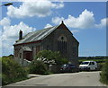
4
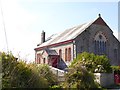
Treverva Methodist chapel
A footpath runs beside the chapel to Helland House Image
Image: © David Smith
Taken: 30 Sep 2015
0.07 miles
6
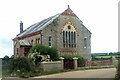
Treverva Methodist Church
Originally a Wesleyan chapel.
Image: © Paul Barnett
Taken: Unknown
0.08 miles
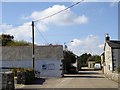
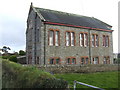
7
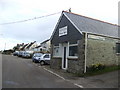
Treverva Village Hall
Recycled from the village shop!
Image: © Jonathan Billinger
Taken: 14 Mar 2007
0.09 miles
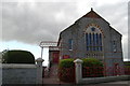
9
Treverva chapel
Treverva Chapel is situated on the road through the village, on the Constantine side. It hosts a thriving male voice choir!
Image: © Jonathan Billinger
Taken: 14 Mar 2007
0.10 miles
10
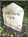
Old Milestone by the B3291, west of Treverva - west face
Carved stone post by the B3291, in parish of BUDOCK (KERRIER District), West end of Treverva; opposite granite cottages, by the road, on North side of road. Erected by the Local Highways Board in the 19th century.
Inscription reads:-
: PENRYN / 3M : : GWEEK / 5 M / LIZARD / 15 M :
Grade II listed.
List Entry Number: 1328473 https://historicengland.org.uk/listing/the-list/list-entry/1328473
Milestone Society National ID: CW_PRGW03.
Image: © Rosy Hanns
Taken: 8 Jun 2019
0.11 miles