IMAGES TAKEN NEAR TO
Lower Treluswell, PENRYN, TR10 9AT
Introduction
This page details the photographs taken nearby to TR10 9AT by members of the Geograph project.
The Geograph project started in 2005 with the aim of publishing, organising and preserving representative images for every square kilometre of Great Britain, Ireland and the Isle of Man.

There are currently over 7.5m images from over14,400 individuals and you can help contribute to the project by visiting https://www.geograph.org.uk
Image Map
Images are licensed for reuse under creativecommons.org/licenses/by-sa/2.0
Notes
- Clicking on the map will re-center to the selected point.
- The higher the marker number, the further away the image location is from the centre of the postcode.
Image Listing (6 Images Found)
Images are licensed for reuse under creativecommons.org/licenses/by-sa/2.0
Image
Details
Distance
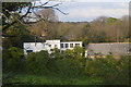
4
Field between B3292 and the Maritime Line
Image: © N Chadwick
Taken: 28 Apr 2018
0.07 miles
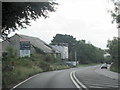
5
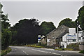
Cornwall : The B3292
A road heading through Cornwall with The Bathroom Shop.
Image: © Lewis Clarke
Taken: 13 Jul 2015
0.09 miles
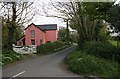
6
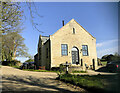
Former Methodist Chapel, Lower Treluswell
It was originally Wesleyan, and is dated no later than 1880, closing in 1954.
Image: © Paul Barnett
Taken: Unknown
0.17 miles