IMAGES TAKEN NEAR TO
Roskrow, PENRYN, TR10 9AR
Introduction
This page details the photographs taken nearby to TR10 9AR by members of the Geograph project.
The Geograph project started in 2005 with the aim of publishing, organising and preserving representative images for every square kilometre of Great Britain, Ireland and the Isle of Man.

There are currently over 7.5m images from over14,400 individuals and you can help contribute to the project by visiting https://www.geograph.org.uk
Image Map
Images are licensed for reuse under creativecommons.org/licenses/by-sa/2.0
Notes
- Clicking on the map will re-center to the selected point.
- The higher the marker number, the further away the image location is from the centre of the postcode.
Image Listing (16 Images Found)
Images are licensed for reuse under creativecommons.org/licenses/by-sa/2.0
Image
Details
Distance

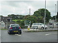
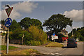
4
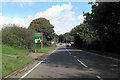
Approaching Treluswell Roundabout
Heading north east towards Truro.
Image: © JThomas
Taken: 5 Nov 2014
0.14 miles
5
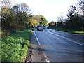
A39 approaches the Treluswell Roundabout
Image: © Stuart Logan
Taken: 13 Oct 2012
0.16 miles
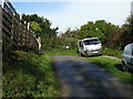
7
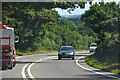
Cornwall : The A39
The A39 heading through the Cornish countryside.
Image: © Lewis Clarke
Taken: 17 Jul 2015
0.17 miles
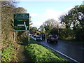
8
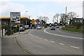
Treluswell Roundabout
The road leading up to one of those complicated double roundabouts beloved of transport planners.
Image: © Tony Atkin
Taken: 29 Apr 2006
0.17 miles
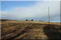
9
Cornwall : The A39
The A39 heads through Cornwall and approaches a roundabout.
Image: © Lewis Clarke
Taken: 17 Jul 2015
0.19 miles