IMAGES TAKEN NEAR TO
Read Close, PENRYN, TR10 8SE
Introduction
This page details the photographs taken nearby to Read Close, TR10 8SE by members of the Geograph project.
The Geograph project started in 2005 with the aim of publishing, organising and preserving representative images for every square kilometre of Great Britain, Ireland and the Isle of Man.

There are currently over 7.5m images from over14,400 individuals and you can help contribute to the project by visiting https://www.geograph.org.uk
Image Map
Images are licensed for reuse under creativecommons.org/licenses/by-sa/2.0
Notes
- Clicking on the map will re-center to the selected point.
- The higher the marker number, the further away the image location is from the centre of the postcode.
Image Listing (3 Images Found)
Images are licensed for reuse under creativecommons.org/licenses/by-sa/2.0
Image
Details
Distance
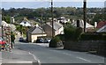
2
Houses, Penryn
The recently developed Trelowen Drive is seen from the footpath below Tregonhaye.
Image: © Andrew Smith
Taken: 21 Sep 2022
0.24 miles
3
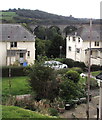
Viaduct arches behind houses, Penryn
Three of the eleven arches of College Wood railway viaduct http://www.geograph.org.uk/photo/1883620 viewed from Saracen Way.
The viaduct carries the Maritime branch line (Truro-Falmouth Docks).
Image: © Jaggery
Taken: 16 Oct 2015
0.25 miles