IMAGES TAKEN NEAR TO
Greenwood Road, PENRYN, TR10 8RG
Introduction
This page details the photographs taken nearby to Greenwood Road, TR10 8RG by members of the Geograph project.
The Geograph project started in 2005 with the aim of publishing, organising and preserving representative images for every square kilometre of Great Britain, Ireland and the Isle of Man.

There are currently over 7.5m images from over14,400 individuals and you can help contribute to the project by visiting https://www.geograph.org.uk
Image Map
Images are licensed for reuse under creativecommons.org/licenses/by-sa/2.0
Notes
- Clicking on the map will re-center to the selected point.
- The higher the marker number, the further away the image location is from the centre of the postcode.
Image Listing (57 Images Found)
Images are licensed for reuse under creativecommons.org/licenses/by-sa/2.0
Image
Details
Distance
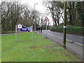
2
Welcome to Mabe Parish modern boundary stone
Image: © Paul Barnett
Taken: 12 Feb 2023
0.03 miles
4
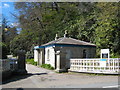
Lodge at the entrance to Tremough College
Originally a country house, Tremough was until relatively recently a convent but it is now the campus for the Combined Universities of Cornwall.
Image: © Rod Allday
Taken: 15 Apr 2008
0.04 miles
5
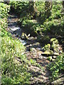
Stream below the road at Packsaddle Penryn
Image: © Rod Allday
Taken: 15 Apr 2008
0.08 miles
6
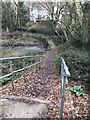
Footbridge over a stream in Tremoughdale
Image: © Paul Barnett
Taken: 12 Feb 2023
0.14 miles
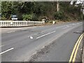
10
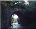
Railway bridge over Treliever Road
An arched bridge with limited headroom.
Maximum headroom 5 metres (16' 6").
Looking east.
Image: © JThomas
Taken: 5 Nov 2014
0.16 miles