IMAGES TAKEN NEAR TO
Saracen Way, PENRYN, TR10 8PR
Introduction
This page details the photographs taken nearby to Saracen Way, TR10 8PR by members of the Geograph project.
The Geograph project started in 2005 with the aim of publishing, organising and preserving representative images for every square kilometre of Great Britain, Ireland and the Isle of Man.

There are currently over 7.5m images from over14,400 individuals and you can help contribute to the project by visiting https://www.geograph.org.uk
Image Map
Images are licensed for reuse under creativecommons.org/licenses/by-sa/2.0
Notes
- Clicking on the map will re-center to the selected point.
- The higher the marker number, the further away the image location is from the centre of the postcode.
Image Listing (133 Images Found)
Images are licensed for reuse under creativecommons.org/licenses/by-sa/2.0
Image
Details
Distance
1
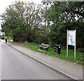
Bench, bin and notice board, Penryn
Alongside Saracen Way.
Image: © Jaggery
Taken: 16 Oct 2015
0.02 miles
2
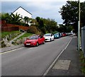
On-street parking in Saracen Way, Penryn
Beyond double yellow lines on the left, where parking is illegal at any time.
Image: © Jaggery
Taken: 16 Oct 2015
0.02 miles
3
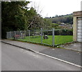
Public area alongside Saracen Way, Penryn
A fence gate gives access to a small grassed area containing a memorial stone and picnic table.
Image: © Jaggery
Taken: 16 Oct 2015
0.03 miles
4
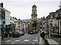
Penryn Town Centre
The prominent building with the clock tower is Penryn Town Hall and Museum, formerly the Market Hall. It sits between Higher Market street on the right and Lower Market Street on the left. The street plan of this area has not changed since this was a medieval market place with the houses and shops at the front of narrow medieval burgage strips. This is still the commercial core of Penryn but it is obviously no longer a major shopping centre as it has been since medieval times. There is distinct lack of the normal high street shops.
Image: © Tony Atkin
Taken: 5 Jul 2006
0.04 miles
5
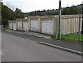
Six lockup garages, Saracen Way, Penryn
Viewed from the corner of Saracen Crescent.
Image: © Jaggery
Taken: 16 Oct 2015
0.04 miles
6
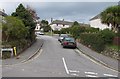
Saracen Crescent towards Saracen Close, Penryn
Viewed across Saracen Way. The right turn behind the two cars is into Saracen Close.
Image: © Jaggery
Taken: 16 Oct 2015
0.06 miles
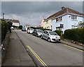
7
Junction in Penryn
Saracen Way is on the right. An unnamed dead-end road on the left descends between houses.
Image: © Jaggery
Taken: 16 Oct 2015
0.06 miles
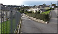
8
Saracen Place, Penryn
Ascending from Saracen Way.
Image: © Jaggery
Taken: 16 Oct 2015
0.07 miles
9
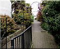
Entrance to Audierne, Penryn
From Lower Market Street, this is the entrance to Audierne,
a sheltered housing complex which is named after Penryn's twin town in Brittany.
Image: © Jaggery
Taken: 16 Oct 2015
0.07 miles
10
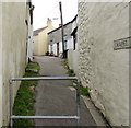
Northern end of Chapel Lane, Penryn
Chapel Lane ascends from Lower Market Street.
Image: © Jaggery
Taken: 16 Oct 2015
0.07 miles