1
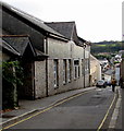
St Thomas Street in Penryn
Looking north-westward.
Image: © Peter Wood
Taken: 4 May 2017
0.02 miles
2
Penryn Library
The St Thomas Street library is part of Cornwall Council's public library service.
Image: © Jaggery
Taken: 16 Oct 2015
0.03 miles
3
Old Fire Station, 2 Broad Street, Penryn
Grade II Listed fire station of 1899. The site had formerly been owned by Penryn MP and Pendennis Castle governor Sir Nicholas Slanning, who died for the royalist cause during the English Civil War. The site was acquired in 1887. Until then it had been a dwelling, and in 1899 a new fire station was built, although reportedly the firemen still had to catch the horses for the engine from a field near St Gluvias Church. It is possible that the building may have re-used earlier elements. The 1940s brought a new fire station and in the decades that followed it was used as a shop, veterinary practice, cafe, and finally in the late 1980s or early 1990s flats, before lying empty from the mid 2000s. In early 2017 application was made to renovate it into two flats.
Image: © Jo and Steve Turner
Taken: 30 Jun 2019
0.04 miles
4
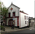
Old Fire Station, Penryn
The former Fire Station building on the corner of Broad Street and St Thomas Street dates from 1899.
The roundel on the wall depicts a fireman's helmet, the metal part of a hosepipe and an axe.
On the lower edge of the roundel are the words ALWAYS READY.
The building was Grade II listed in 1971.
Image: © Jaggery
Taken: 16 Oct 2015
0.04 miles
5
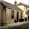
The former fire station, Penrhyn
Fire engines were evidently small in those days.
Image: © Humphrey Bolton
Taken: 6 Jan 2016
0.04 miles
6
Ordnance Survey Cut Mark with Bolt
This mark can be found on the roadside wall of a building in Broad Street, Penryn. The benchmark height is recorded as being 19.3931 metres above sea level.
For more detail see : http://www.bench-marks.org.uk/bm24772
Image: © Peter Wood
Taken: 4 May 2017
0.05 miles
7
The Club, Broad Street, Penryn
Social club at 1 Broad Street, on the corner of New Street.
The Kings Arms Hotel http://www.geograph.org.uk/photo/4702957 is on the right.
Image: © Jaggery
Taken: 16 Oct 2015
0.05 miles
8
New Street, Penrhyn
One of three narrow lanes leading from the main street down to Church Road.
Image: © Humphrey Bolton
Taken: 6 Jan 2016
0.05 miles
9
Old road direction sign, Penrhyn
This certainly looks genuine, with raised lettering and small pits that would presumably have been filled with reflective studs. Hopefully it has been left in place as 'Heritage'.
Image: © Humphrey Bolton
Taken: 6 Jan 2016
0.05 miles
10
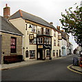
Kings Arms Hotel, Broad Street, Penryn
Bar & restaurant, with bed & breakfast accommodation available.
Image: © Jaggery
Taken: 16 Oct 2015
0.05 miles


